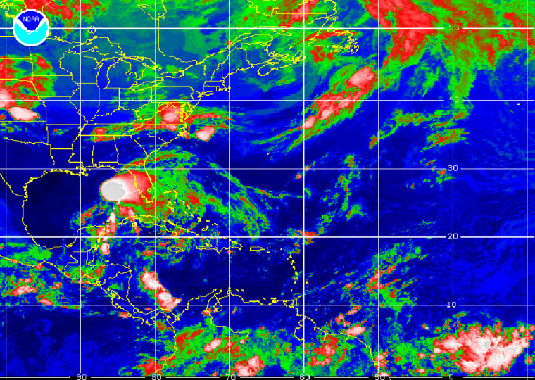
Most of Florida’s west coast was under a tropical storm watch Sunday as the first named storm of the 2006 Atlantic hurricane season spun over the Gulf of Mexico, threatening to bring heavy rain in the next few days.
Tropical Storm Alberto had maximum sustained wind near 45 mph, up 10 mph from the morning, but it was not likely to grow into a hurricane, the National Hurricane Center said.
“We do not have any significant changes,” said Lixion Avila, a senior hurricane specialist. “The system remains poorly organized.”
Alberto is a lopsided tropical storm with the most intense wind and rains massed on the eastern edge of the system, Avila said. The first of the storm’s rains swept across the Florida peninsula Sunday with no major reports of damage.
Forecasters said 30 inches of rain could fall over the western half of Cuba, creating a threat of flash floods and mudslides, while 5 to 10 inches were possible over the Florida peninsula and 3 to 5 inches could fall over the Keys through Tuesday.
'We’re carrying on as usual'
The prospect of a wet storm without hurricane-force wind was welcomed by firefighters who have been battling wildfires for six weeks on Florida’s east coast.
“A good soaking rain would do a lot to help stop the fires in our area,” said Pat Kuehn, a spokeswoman for Volusia County Fire Services. “It has been a hard fire season. We’ve had several fires a week here.”
Residents of the state’s Gulf Coast were watching the storm, including Patricia Haberland, whose back porch was flooded by 12 inches of rain in March. She put a few valuables in plastic bins this weekend just to be on the safe side.
“Other than that, we’re carrying on as usual, going to work, going to church,” said Haberland, 52. “It doesn’t look like it’s going to have a major impact on our area.”
The storm was not expected to cross the Keys, but some tourists were not taking any chances on the low-lying islands.
“I had a bunch of people check out this morning,” said Nikki LaMarca, front desk manager at Courtney’s Place in Key West. “It’s amazing. People are actually leaving.”
At 2 a.m. EDT, Alberto was centered about 340 miles south-southwest of the Florida Panhandle, forecasters said early Monday.
It was moving north-northeast at about 6 mph, and was to turn northeastward in the direction of central or northern Florida, where it could make landfall early Tuesday, forecasters said.
No guarantee of landfall
The tropical depression that produced Alberto formed Saturday, nine days after the official start of the hurricane season, in the northwest Caribbean, which can produce typically weak storms that follow a similar track this time of year, forecasters said.
“They can also meander in the Gulf for awhile, and we’ve seen some dissipate before reaching any land areas,” said hurricane specialist Richard Pasch. “There is no guarantee (Alberto) will make landfall.”
Scientists say the 2006 season could produce as many as 16 named storms, six of them major hurricanes.
Last year’s hurricane season was the most destructive on record. Hurricane Katrina devastated Louisiana and Mississippi and was blamed for more than 1,570 deaths among Louisiana residents alone.
It also was the busiest in 154 years of storm tracking, with a record 28 named storms and a record 15 hurricanes. Meteorologists used up their list of 21 proper names — beginning with Arlene and ending with Wilma — and had to use the Greek alphabet to name storms for the first time.
This year, however, meteorologists have said the Atlantic is not as warm as it was at this time in 2005, meaning potential storms would have less of the energy needed to develop into hurricanes.
Last year’s first named storm was Tropical Storm Arlene, which formed June 9 and made landfall just west of Pensacola in the Florida Panhandle.
