One sheer drop-off to the right, another eight feet to the left. A switchback ridge so steep that three steps brings you to the next turn. Rope handholds to clutch when the mountain trail shrinks to less than a foot wide.
What am I, a goat? It was time to consider a panic attack. A summer day hike, my husband said. A glorious saunter up a flower-filled meadow to one of the world’s most famous Alpine huts. Look, families with little children are in the gondola line with us. Don’t forget your sunglasses, it’s so bright.
Which is how, three hours later, I was shivering in a surprise July snowstorm en route to Hoernlihuette, the Matterhorn base camp, wearing capris and sneakers with no tread.
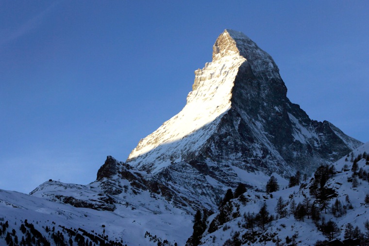
At 14,690 feet, the Matterhorn is not even the highest mountain in Switzerland - but it surely is the most photogenic, rising up on four elegant faces to a craggy peak along the Swiss-Italian border. Walt Disney even borrowed its silhouette for Disneyland, debuting the Matterhorn Bobsleds ride in 1959.
At the real mountain’s base lies the car-free Swiss town of Zermatt. There is no offseason here; it’s nearly always packed with tourists riding trains and gondolas up the mountains, hiking on the alpine trails, walking along picturesque streets lined with traditional chalets, and eating at restaurants decorated with the ubiquitous, huge Swiss cowbells. Utterly charming or tourism
gone mad, depending on your point of view.
Hoernlihuette, at 10,696 feet, has been on the flank of the mountain in some version since 1880. It’s where the guys and gals with ice picks, ropes and crampons eat, drink, sleep and use the outhouse before launching their pre-dawn summit attempts. When the weather is bad and no one sits on the patio, you can also inhale the wet socks and sweaty shirts of manly men who disdain deodorant.
About 4,000 people a year stay here during its brief summer season (July 1 to Sept. 30), with 3,000 of them seeking glory on top of the Matterhorn. But I was of the lesser beings, daytrippers who gasp for breath up to the stone refuge, throw themselves exhausted upon its sturdy wooden benches and need a beer - or maybe two - before they can face the trials of going back down.
We set off for Hoernlihuette on a crisp sunny morning, after a brief walk around Zermatt and a stop to pick up water and munchies. Then we were off to the Schwarzsee cable car, which whisked us 3,000 feet up to a restaurant and pond above the tree line, where families with children picnicked.
For hikers, it was time to get started, at 8,474 feet. After 45 minutes across a stony meadow, we reached Hirli, a lone building a few hundred feet up. My, how time flies on a mountain. You can see where you are going, yet it takes forever. To match my plodding pace, my husband photographed about 10,000 alpine flowers from every direction.
Slideshow 23 photos
A European tour
Then the wind turned brisk, the blue sky ashen gray. Temperatures fell about 20 degrees. We broke out the windbreakers, which held off the freezing rain for five to six minutes tops. I longed for gloves and a hat.
It took about 10 steps for the landscape to turn from alpine meadow to crumbling lunar rock face. As the sleet turned into stinging hail, the trail disappeared altogether.
The snowstorm struck when we were totally exposed on the switchback ridge. By then I was hyperventilating about the sheer cliffs on either side. I decided it was better to stare at the wet stones beneath my feet.
Ironic, is it not, that we seek out these sweeping mountain vistas, yet when we are there, a glance in any direction sends our hearts racing in fear?
Yet the mind is a marvelous thing. Since the storm limited visibility to six feet, all of a sudden I could not see the plunging cliffs. Death might be a step or two away, but I was oblivious. That’s when the fear disappeared.
We somehow made it to Hoernlihuette. Fortified by gemuesesuppe (vegetable soup) and heisse schokolade (hot chocolate), we left the steamy camp about 3:15 p.m., just as the next day’s summiteers were checking in for the night. There’s nothing like a one-inch layer of sleet and a pea soup-thick fog to really make a mountain descent interesting - I thanked God again and again for my two adjustable hiking poles.
As we drew near to Schwarzsee, we heard a shout. A climber with a fully loaded expedition backpack was practically dancing down the mountain, leaping from rock to rock, his ice pick swinging. We flattened against the cliff to let him pass. A minute later, another. Then six, then a dozen.
“Maybe they are racing,” I mused. We soon found out why, as we watched the gondola operator lock up his office and ride the last one down, despite our own shouts from 100 yards away. We had misread the 17:15 p.m. closing time as 7:15 p.m. In fact, 17:15 p.m. is 5:15
p.m. We arrived at 5:21 p.m., six minutes too late. Believe me, he did not care.
Now we had 3,000 feet more to go, or 2 hours and 35 minutes to Zermatt,
according to a trail sign.
A word about those Swiss hiking times posted at every crossroads. Would you ask a Kenyan how long it takes to run to the nearest village? I think not. Swiss grandmothers could beat you up the mountain carrying their day’s groceries, so why would you believe their time estimates?
You can’t. Try adding 25 minutes for every hour. Then add another 35 minutes because it is dark and you have to stick to the winding road instead of hitting the steep yet enticing trails through the woods that you know could save you miles. Memo to self: Buy a hiking head lamp.
After three more hours, my thigh muscles began to twitch uncontrollably. Nearly frozen, we arrived back in the dark, utterly exhausted, about 9 p.m. What did we learn?
- Zermatt and the Matterhorn are must-see destinations.
- Mountain expeditions in capris and bald sneakers are bound to end in
disaster. - The Swiss are nothing if not punctual _ do not miss the last tram.
- Over 500 people have died climbing the Matterhorn since 1865, and Swiss
tourism authorities say deaths now average about 12 annually. (WHAT? WHAT? A
dozen each year? Could someone have mentioned this sooner?) As of early May, six
people had died this year.
Many of the dead mountaineers are buried in Zermatt’s downtown cemetery.
Don’t join that club.

