Deep enough to hold the combined water in all the other Great Lakes and with a surface area as large as South Carolina, Lake Superior's size has lent it an aura of invulnerability. But the mighty Superior is losing water and getting warmer, worrying those who live near its shores, as well as scientists and companies that rely on the lake for business.
The changes to the lake could be signs of climate change, although scientists aren't sure.
Superior's level is at its lowest point in eight decades and will set a record this fall if, as expected, it dips three more inches. Meanwhile, the average water temperature has surged 4.5 degrees since 1979, significantly above the 2.7-degree rise in the region's air temperature during the same period.
That's no small deal for a freshwater sea that was created from glacial melt as the Ice Age ended and remains chilly in all seasons.
A weather buoy on the western side recently recorded an "amazing" 75 degrees, "as warm a surface temperature as we've ever seen in this lake," said Jay Austin, assistant professor at the University of Minnesota at Duluth's Large Lakes Observatory.
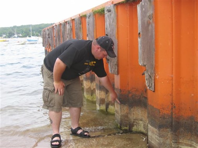
Water levels also have receded on the other Great Lakes since the late 1990s. But the suddenness and severity of Superior's changes worry many in the region. Shorelines are dozens of yards wider than usual, giving sunbathers wider beaches but also exposing mucky bottomlands and rotting vegetation.
On a recent day, Dan Arsenault, a 32-year-old lifelong resident of Sault Ste. Marie in Michigan's Upper Peninsula, watched his two young daughters play in mud on the southeastern coast where water was waist deep only a few years ago. A floatation rope that previously designated the swimming area now rests on moist ground.
"This is the lowest I've ever seen it," said Arsenault.
Superior still has a lot of water. Its average depth is 483 feet and it reaches 1,332 feet at the deepest point. Erie, the shallowest Great Lake, is 210 feet at its deepest and averages only 62 feet. Lake Michigan averages 279 feet and is 925 feet at its deepest.
Docking problems
Yet along Superior's shores, boats can't reach many mooring sites and marina operators are begging the U.S. Army Corps of Engineers to dredge shallow harbors. Ferry service between Grand Portage, Minn., and Isle Royale National Park was scaled back because one of the company's boats couldn't dock.
Sally Zabelka has turned away boaters wanting to dock at Chippewa Landing marina in the eastern Upper Peninsula, where not long ago 27-foot vessels easily made their way up the channel from the lake's Brimley Bay. "In essence, our dock is useless this year," she said.
Another worry: As the bay heats up, the perch, walleye and smallmouth bass that have lured anglers to her campground and tackle shop are migrating to cooler waters in the open lake.
Low water has cost the shipping industry millions of dollars. Vessels are carrying lighter loads of iron ore and coal to avoid running aground in shallow channels.
Puffing on a pipe in a Grand Marais pub, retiree Ted Sietsema voiced a suspicion not uncommon in the villages along Superior's southern shoreline: The government is diverting the water to places with more people and political influence — along Lakes Huron and Michigan and even the Sun Belt, via the Mississippi River.
"Don't give me that global warming stuff," Sietsema said. "That water is going west. That big aquifer out there is empty but they can still water the desert. It's got to be coming from somewhere."
That theory doesn't hold water, said Scott Thieme, hydraulics and hydrology chief with the Corps of Engineers district office in Detroit. Water does exit Lake Superior through locks, power plants and gates on the St. Marys River, but in amounts strictly regulated under a 1909 pact with Canada.
Less precipitation, more evaporation
The actual forces at work, while mysterious, are not the stuff of spy novels, he said.
Precipitation has tapered off across the upper Great Lakes since the 1970s and is nearly 6 inches below normal in the Superior watershed the past year. Water evaporation rates are up sharply because mild winters have shrunk the winter ice cap — just as climate change computer models predict for the next half-century.
Yet those models also envision more precipitation as global warming sets in, said Brent Lofgren, a physical scientist with the Great Lakes Environmental Research Laboratory in Ann Arbor. Instead there's drought, suggesting other factors.
Cynthia Sellinger, the lab's deputy director, said she suspects a contributing factor could be residual effects of El Nino, the warming of equatorial Pacific waters that produced warmer winters in the late 1990s, just as the lakes began receding.
Austin, the Minnesota-Duluth professor, said he's concerned about the effects the warmer water could have.
"It's just not clear what the ultimate result will be as we turn the knob up," he said. "It could be great for fisheries or fisheries could crash."
