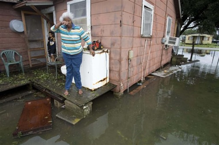
Humberto, which grew faster than any storm on record from tropical depression to full-scale hurricane, surprised the Texas-Louisiana coast with 85-mph (137-kph) winds and heavy rain that knocked out power to more than 100,000 and left at least one person dead.
Meanwhile, Tropical Storm Ingrid formed late Thursday in the open Atlantic Ocean, but it was far from land.
Meteorologists were at a loss to explain the rapid, 16-hour genesis Thursday of Humberto, the first hurricane to hit the U.S. since 2005.
"Before Humberto developed, you looked at the satellite imagery the day before, and there was virtually nothing there. This really spun up out of thin air, very, very quickly, said National Hurricane Center specialist James Franklin in Miami. "We've never had any tropical cyclone go from where Humberto was to where Humberto got."
Surprising as Humberto was, forecasters said it may have been a blessing that it did not linger longer over warm waters of the Gulf of Mexico, which could have given it time to develop into more than a minimal hurricane.
Texas coastal residents prepared for a tropical storm rainmaker that would quickly flood the ground already saturated from the wettest summer in 60 years. Although forecasts called for up to 1 foot (30 centimeters) of rain, Humberto produced no more than half that and generated much more wind. By late afternoon, it had weakened to tropical depression churning across the southern U.S.
"We feel very fortunate and blessed it wasn't worse," said Beaumont resident Edward Petty, 50, who was clearing debris outside his home 50 miles (80 kilometers) northeast of High Island, near where the storm came ashore.
'Hunker down'
"It was amazing to go to sleep to a tropical storm and wake up to a hurricane," he said. "What are you going to do? You couldn't get up and drive away. You couldn't run for it. You just have to hunker down."
The only reported death was a man who died in southeast Texas when the carport at his home collapsed, police said.
Humberto made landfall less than 50 miles (80 kilometers) from where Hurricane Rita did in 2005, and areas of southwest Louisiana not fully recovered from Rita were bracing for more misery.
"I'm in a FEMA trailer (because of Rita) and I'm on oxygen," said Albertha Garrett, 70, who spent the night at a shelter in the Lake Charles Civic Center. "I had to come to the civic center just in case the lights would go out, because I'm alone and I'm handicapped."
About 118,000 customers were out of power in Texas and Louisiana at one point, utility officials said.
Along Port Arthur's refinery row, three plants were idled until power was restored. Some of the plants could be off-line for several days, even after power is restored, because they must undergo the full restart process.
Hurricane center forecasters first mentioned what would become Humberto on Saturday, when it was a disorganized system of showers and thunderstorms stretching from Cuba west over the southern Gulf of Mexico.
By 11 a.m. (1500 GMT) Wednesday, it had organized into a tropical depression with 35 mph (56 kph) winds and by 2 p.m. was a 45-mph (72-kph) tropical storm, centered just 70 miles (115 kilometers) off shore. At 1:15 a.m. Thursday, it was upgraded to an 80-mph (129-kph), Category 1 hurricane, only 15 miles (24 kilometers) from the coast. Less than two hours later, at 3 a.m. (0700 GMT), its center roared ashore with 85-mph (138-kph) winds just east of High Island.
From depression to hurricane
Only three other storms have pulled off a similar feat, growing from depression to hurricane in 18 hours _ Blanche in 1969, Harvey in 1981 and Alberto in 1982 _ but all of them were out at sea at the time, not about to crash ashore like Humberto.
Experts cannot draw conclusions on possible trends of faster-forming hurricanes based on just one storm. Franklin said part of the problem was Humberto was a relatively small-sized storm, making it harder for forecasters and computer models to analyze.
One possibility, he said, is that because Humberto was close to landfall, greater friction between air currents and the ground could have forced winds upward into the storm and lended to its intensification.
Kerry Emanuel, a meteorology professor at the Massachusetts Institute of Technology, said it is not so much the positive factors like warm Gulf of Mexico waters that help fuel storms like Humberto to intensify quickly. It is the lack of negative factors like wind shear that would weaken a storm.
The most destructive natural disaster in U.S. history, 2005's Hurricane Katrina, also developed quickly before its first landfall near Miami. It went from a tropical depression to a hurricane in just over two days before hitting Florida. It leveled parts of the Gulf Coast a few days later, part of the busiest hurricane season ever recorded with Rita and Wilma.
Meanwhile, Tropical Storm Ingrid formed in the open Atlantic Ocean on Thursday night, the National Hurricane Center said. It was the ninth storm of the Atlantic hurricane season.
At 11 p.m. Thursday (0300 GMT Friday), Ingrid's center was located about 840 miles (1,350 kilometers) east of the Lesser Antilles.
Ingrid was moving toward the west-northwest near 6 mph (10 kph) and was expected to continue at that pace for the next 24 hours.
Maximum sustained winds were near 40 mph (64 kph) with higher gusts. Tropical storm force winds extend outward up to 50 miles (80 kilometers) from the center.
