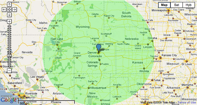
Remember the old song "500 Miles Away From Home"? Think of it as a challenge instead of a lament and you could come up with some good ideas for a road trip.
You can do it the old-fashioned way, calculating distances on a paper map using scale of miles and a ruler. But now there are free online map radius tools that show you at a glance which destinations are within a given distance.
One that's relatively simple to use is at freemaptools.com/radius-around-point.htm.
Go to the Web site and scroll down to the "Options" form. Type in the city you're starting from in "Place radius by location name."
Skip latitude and longitude and go to the "Radius Distance" section. Here the form automatically sets the radius distance to 1,000 kilometers, but you can reset by typing in the number of miles you're willing to drive in the "miles" box right next to the kilometer box.
Now go back up to the location name and click on "Draw Radius."
Scroll up to see the green circle on the map. Zoom in by grabbing the minus sign on the left and moving it up a couple of notches for a more detailed look at cities within your drive-to zone.
Depending on traffic and highway speed, most people can easily cover 500 miles in a day's drive, so starting with that distance could inspire some interesting choices. If you're taking a week's vacation, driving the first and last days to and from your destination is often an acceptable tradeoff to save on plane fare.
Starting with New York as a radius point on the FreeMapTools.com Web site, you quickly see that trips to Montreal, Toronto, Cleveland and Virginia Beach, Va., are well within the 500-mile radius.
Destinations at the very edge of the circle may be farther than your maximum distance once you calculate actual driving routes. The radius tool measures distance as the crow flies without considering highways or terrain, so it's good to check distances against a mileage calculator on MapQuest or GoogleMaps.
Safely inside the 500-mile circle around New York, the actual distance to Toronto is 475 miles; to Cleveland, 463 miles; to Montreal, 376 miles; and to Virginia Beach, Va., 362 miles. Greenville, N.C., appears near the edge of the 500-mile circle, and GoogleMaps' mileage calculator says the driving distance is just beyond 500 miles, at 522.
Checking out a few other starting points yields some great vacation ideas within a 500-mile circle: Baltimore to Myrtle Beach, S.C.; Denver to Mount Rushmore; Cleveland to Mammoth Cave in Kentucky; Minneapolis to Kansas City; Tucson to Los Angeles; Atlanta to Orlando; Boise, Idaho, to Portland, Ore.; Helena, Mont., to Salt Lake City.
If you're willing to make the seven-to-10 hour drive, the cost savings of a 500-mile road trip versus flying is considerable. For one person, it's not that much, but a family of four is likely to spend over $1,000 flying anywhere round-trip. Air travel also involves more than the cost of plane tickets; there's transportation to and from the airport, food and other incidentals, and car rental when you land.
In contrast, with gas around $2 a gallon, driving 1,000 miles in a car that gets 25 mpg will cost you well under $100. Even counting tolls, food and a night in a motel en route if you can't make the trip in a day, it's bound to run less than plane tickets. If you're feeling ambitious, leave before dawn and you can easily get to a destination 400 miles away by lunchtime.
Or if you're willing to leave at dawn and arrive by dinner, expand your radius to 800 miles and you greatly expand your vacation options. My husband and I managed to drive the 840-mile trip from New York to Mammoth Cave in one day with two kids (and no electronic devices to entertain them), and had a cheap and unforgettable vacation visiting the national park and nearby attractions.
While using a map radius can expand your list of potential vacation spots, the appeal is partly psychological. Many people are not good at estimating distances, and knowing exactly how far away something is can make it seem more attainable.
Besides, quantifying distances is something of a national pastime. Of course there are thousands of highway mileage signs that list distances to other cities, but there are also numerous examples of whimsical or wistful mileage signs.
U.S. soldiers on bases overseas sometimes erect handmade signposts listing the mileage to their favorite places and hometowns thousands of miles away. A sign in downtown Anchorage notes the distance to Tokyo and Paris. Many small towns in Maine are named for big cities around the world, so there are famous signposts at local crossroads showing place names like China, Norway, Mexico and Paris just a few miles down the road.
And when you get to the top of Mount Katahdin in Maine at the northern terminus of the Appalachian Trail, you're confronted with a sign that tells you Springer Mountain, Ga., at the southern end of the trail, is a mere 2,000 miles away.
