Nearly 200 years before Hurricane Katrina struck New Orleans, a major storm hit the coast of Louisiana just west of the city.
Unfortunately for modern meteorologists who want to study past hurricanes, the War of 1812 was raging and details such as the hurricane's strength and direction were quickly forgotten or never recorded.
"It was a lost event, dwarfed by history itself," said study author Cary Mock, a geographer at the University of South Carolina. "Louisiana was just in possession by the United States at the time, having been purchased from France only years before, and was isolated from the press."
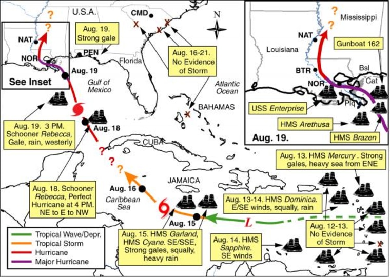
But using maritime records, Mock was able to reconstruct details of the storm. Reconstructing past hurricanes could help climatologists forecast and track hurricanes today.
Among the worst
The hurricane made landfall on Aug. 19, 1812. It was stronger than Hurricane Katrina and it hit closer to the city, Mock said.
"A hurricane like the one in August 1812 would rank among the worst Louisiana hurricanes in dollar damage if it occurred today," Mock said. "Hurricane Betsey (1965) was 100 miles to the west. Katrina was to the east. A 1915 hurricane came from the south. By knowing the track and intensity, as well as storm surge, of the August 1812 hurricane, we have another worst-case-scenario benchmark for hurricanes. If a hurricane like it happened today — and it could happen — it would mean absolute devastation."
Newspaper accounts from the time, which included five from Louisiana and 17 from other states, described hourly timing of the storm's impact, wind direction and intensity, rainfall, tide height and damage to trees and buildings. The Orleans Gazette's description of the impact of storm surge on the levees is one example:
"The levee almost entirely destroyed; the beach covered from fragments of vessels, merchandize, trunks, and here and there the eye falling on a mangled corpse. In short, what a few hours before was life and property, presented to the astonished spectator only death and ruin."
Different conditions
The environmental conditions of the Louisiana coast were different in 1812; the sea level was lower, the elevation of the city was higher and the expanse of the wetlands that can help protect the city far greater. These conditions would have reduced the storm surge by at least several feet, Mock said. The storm's initial approach was toward Mississippi, but then it turned northwest toward Louisiana as it approached landfall in the afternoon on Aug. 19, Mock said.
Using the ship logs and protests, Mock was able to create a map of the storm's path through the Gulf of Mexico. To understand the hurricane's formation and dissipation, Mock reviewed records stretching as far north as Ohio and east to South Carolina.
"I wanted to collect data from a wide area to understand the weather patterns, pressure systems and the very nature of the 1812 hurricane," Mock said. "A better understanding of hurricanes of the past for a wide area provides a better understanding of hurricane formation and their tracks in the future."
The study is detailed in the December edition of the Journal of the American Meteorological Society.
