I’ll never forget a conversation I had 15 years ago with paleontologist Stephen Jay Gould. He told me and several colleagues that he was basically tired of environmentalists talking about "saving the planet." He flung his arms wide and told us that "if the history of the Earth is my wingspan, all of human history would represent a sliver of my fingernail."
His point? "The planet will be fine … it will just turn into something not so good for people.” So, we should stop talking about saving the planet and start talking about saving ourselves.
We’ve enjoyed great progress in recent years toward understanding and accounting for the value nature provides to people — not just the social and emotional values we’re accustomed to hearing about, but also the hard economic values of nature’s services.
In Nepal, tiger tourism accounts for 50 percent of the revenue some local communities bring in each year. The tiger also features prominently in the stories and teachings of Buddhism. But the tiger’s habitat may be where the greatest value lies.
Protecting the forest is good for tigers, but is also a plus for protecting water quality and quantity. During my last trip, I visited a community where recently restored forests brought a long-dead freshwater spring back to life. A healthy forest also purifies air and provides products such as timber and medicines. Forests also sequester carbon.
The destruction of forests ranks as the second-leading cause of climate change — after the burning of fossil fuels — accounting for up to 20 percent of global carbon pollution. Recognizing this connection last December in Cancun, the countries of the world established the ground rules for a mechanism known as REDD — reducing emissions from deforestation and forest degradation.
REDD works by recognizing and quantifying one of the great values of standing forests: removing and storing harmful carbon pollution. If a country can show that it has reduced its level of deforestation (and the related carbon pollution), then it will receive payments. These payments could come from other governments or from corporations looking to reach climate goals.
Great idea, but only if you can accurately draw up a balance sheet of carbon-in, carbon-out. No one in their right mind would put money into a market with a broken ticker. Until recently, measuring carbon has been too complicated, too costly and altogether inaccurate.
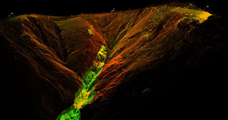
An unlikely solution: lasers being shot from planes at 200,000 photons per second. In a nutshell, that’s LiDAR — Light Detection and Ranging.
It’s not impossible to collect forest structure data by measuring trees on the ground. But anyone who has spent some time on the forest floor in, say, the Peruvian Amazon, can attest to how tough that is. It’s not the venomous snakes, aggressive insects and oppressive heat that are necessarily the issue. Try to put a tape measure around a tree whose diameter doesn’t even come close to a circle, or one with flaring, head-high buttresses that ward off even the most accomplished tree-climbers. Try to estimate height amidst throngs of choking lianas where each tree disappears into a cacophony of green several hundred feet up in the air. It’s not impossible, but it certainly isn’t easy, fast or cheap.
With LiDAR, we can calibrate aerial images with a smattering of ground plots administered by scientists. The results are calculated to create an algorithm that enables you to use satellite imagery not just to count the trees, but also the carbon they contain. A year and a half ago, we flew with the Stanford University Carnegie Airborne Observatory’s Greg Asner over those very impossible-to-measure forests of the Peruvian Amazon and mapped the structure of 11 million acres in 3 weeks. That’s a structural analysis of a forest down to one meter for an area the size of Switzerland — and completed for just a few cents an acre.
LiDAR, the small number of ground plots, and the algorithms that get you from forest structure to carbon quantities are cheap, accessible and incredibly accurate. Those data are also, I think it’s fair to say, empowering: they give developing countries a tool to garner much needed financial resources, reduce global carbon emissions and slow the sickening trend of deforestation.
Working with partners, we’ve already begun using LiDAR to measure the carbon value of the forests of Nepal’s Terai Arc that our recently released tiger calls home. The second flyover is now over in Nepal and we will be able to use that information to help the country participate in the new REDD mechanism. After Nepal, we’re taking the technology to Thailand.
WWF’s ambitious goal for tigers is to double the remaining 3,200 in the wild over the next 12 years; combined with REDD, our efforts can go a long way to preserving the last great forests of Asia — forests that billions of people also depend on for drinking water, sustenance, climate mitigation and their livelihoods.
It’s tempting to look at LiDAR and declare you’ve found the Holy Grail. It’s not. We still need voluntary financial commitments from governments; we still need regulatory frameworks; we still need the conviction of political leaders not to lose this precious resource. But I’m quite confident that LiDAR is the most powerful tool we have for quantifying the value of standing forests all over the world and avoiding their ruin in the process.
It also produces very cool images.
As president and CEO of WWFUS, Carter Roberts leads World Wildlife Fund’s work to save endangered species and their habitats through innovative programs with governments, businesses and local communities throughout the world. WWF, famous for its panda logo, is the world largest conservation network, with over 6 million members and programs across 100 countries. He is the author of The Book of Life: An Illustrated History of the Evolution of Life on Earth.
More tech and innovation stories from Fast Company:
