A central part of our preparation to visit North Korea's Sohae Satellite Station involved studying satellite imagery of the facilities there — and guessing exactly what they were showing. Establishing "ground truth" for analysis performed using photographs taken hundreds of miles overhead is always important, especially in assessing how much to trust similar analyses of other sites that have never actually been seen up close.
So imagine my delight on Sunday as our special train slowly pulled up to the northern boundary of the site, to see that the main gate and guard house were exactly where the photographs indicated they would be. Even the prediction about road surface was confirmed — a hard dirt surface outside the base became a paved road once the gate had been passed.
Even more satisfying was an eyeball examination of an odd building on the east side of the road. It had been seen in satellite images to have had its roof rushed to completion in the last few weeks. And there it was, its roof finally complete. But as we rode past, we could see in the front windows and right out the back ones, showing that its interior remained to be completed.
The 13-car luxury train pulled right up where we expected, at a concrete unloading apron attached by short road to the vehicle assembly building. After an energetic but brief security search at the edge of the unloading zone, our group straggled out to the main north-south thoroughfare easily visible in the space images, then turned south and quickly made a right turn into the assembly building parking lot.
There at the gate I knew that the most delicious "known unknown" of the base layout would be awaiting me. Only days before our visit, the color of the parking lot's concrete had suddenly changed from a dull gray to a strange dark green. Was it deliberate camouflage, to reduce the building’s visibility from space — or something entirely innocent?
The cause of the change was obvious as soon as I passed the gate. The concrete had been covered over by a tarlike layer that looked straight black, not green-tinged at all. It was not just a thin paint layer, but was about an eighth of an inch thick. But as for why it had been applied — that question remained unanswered.
Getting our bearings
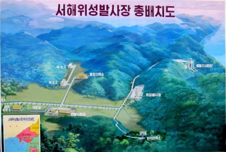
The main item of exhibition inside the hall was the actual satellite, but what struck my eye immediately upon entering was something entirely unexpected — a floor-to-ceiling mural with a stylized map of the entire base.

Sadly, it was labeled only in Korean. But our guide explained most of the facilities during a brief introduction, and our interpreter helped with the rest. During the few hours that followed, we visited or passed near most of the facilities, confirming their functions.
The launch pad was easy to identify, as was the base administration building and the vehicle assembly building. But the base’s other main building had been wrongly identified, seriously so.
Called a "high bay processing facility" in most Western interpretations, the building was due east of the assembly hall and was the only other facility besides the hall that had a security fence around it. It also had seen its cement forecourt suddenly change color a few days before we got there, the only other building to undergo that cosmetic retouching. Meanwhile, another facility atop a hill to the west of the launch pad was called the launch control center.
What we found out was that the so-called "control center" on the hill was just an observation point, probably for VIPs — and the real Launch Control Center was in the important fenced building mislabeled as the high-bay facility. Our earlier impression would have led to a serious misunderstanding of the function of the base.
This isn’t just an issue for the North Korean rocket base. Interpretation of satellite images of other inaccessible facilities — think Iran, for example — may be critical to future military options and planning, and errors can have profound costs.
Recognizing the clues
Visiting a previously closed site opens up the opportunity for stumbling across unexpected clues to lingering mysteries, clues that even top-security censors fail to recognize and protect. Noticing them takes a trained alertness and awareness of their significance — something I like to think I’ve developed from long experience at sleuthing out space secrets.
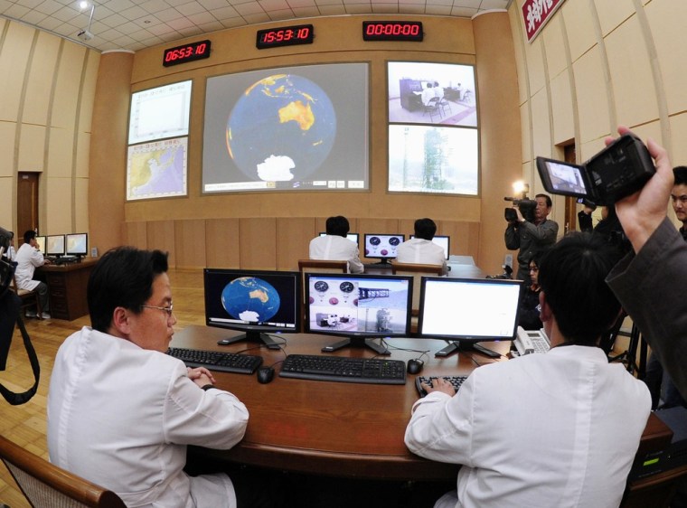
One such clue was on display inside the launch control center.

A lingering mystery of the upcoming launch is the design of the ascent profile to put the satellite in its planned 312-mile-high (500-kilometer-high) orbit. The most efficient path is to get quickly into a low but fast orbit, coast higher for about half an hour, and then fire a rocket again. But this is a sophisticated maneuver, probably beyond the prowess of a fledgling space player.
The other approach is to "loft" the rocket to get to the high altitude quickly. This is wasteful of fuel, and it makes the trajectory look awfully similar to a long-range surface-to-surface missile flight plan. Those are good reasons to try to avoid it.
Which course will the North Koreans choose?. There was a chart on the front screen of the control center for displaying the rocket’s climb into space, with altitude plotted against range from the launch pad. For security purposes, that screen showed no flight path, not even a sample one. But what it did show was all we needed to know.
The chart listed the range of values on the vertical and horizontal scales. For range from launch there were marks every 500 kilometers, out to 3,000. And for altitude, there were marks every 200 kilometers, up to 800. And that clue told the tale. If you're plotting a flight path up to or even a little above 500 kilometers during the initial launch period — as the scale of this chart indicated — you will be using an inefficient and somewhat weapons-like ‘lofted’ path.
There are more clues still to be tracked down, and if they check out, we'll have a much better understanding of North Korea's mysterious space shot.
More about the North Korea and its rocket program:
- North Korea shows off its launch pad and satellite
- Q&A: Rocket is 'not a military missile ... but it's darn close'
- Three Asian airlines avoiding North Korean rocket path
- World News: NBC gets a rare peek inside North Korea
- PhotoBlog: Pictures from the North Korea rocket tour
- Inside North Korea: Closely watched launch poses risks
- North Korea's launch sparks more worries than Iran's
- N. Korea reportedly test-fires short-range missiles
- A look at North Korea's rocket technology
NBC News space analyst James Oberg spent 22 years at NASA's Johnson Space Center as a Mission Control operator and an orbital designer. He is the author of several books on space history and space policy, including "Star-Crossed Orbits: Inside the U.S.-Russian Space Alliance."