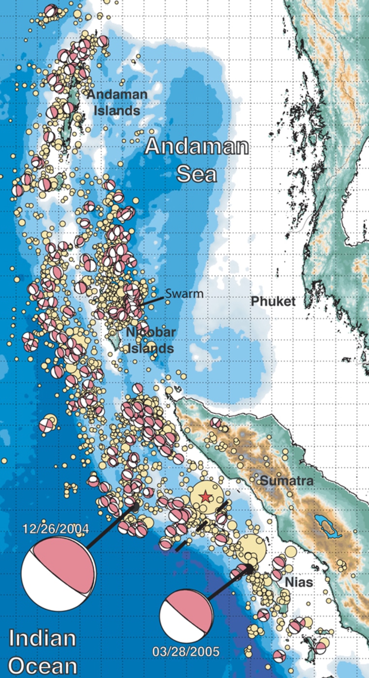
The great Sumatra-Andaman earthquake that generated the devastating tsunami in December was so powerful that the ground shook everywhere on Earth’s surface, and weeks later the planet still trembled.
“No point on Earth remained undisturbed,” said Roger Bilham of the University of Colorado.
Ground movement of at least 0.4 inch (1 centimeter) occurred everywhere as a result of the strongest quake in more than 40 years, though the sensation was not noticed in many areas.
The quake resulted from the longest fault rupture ever observed — 720 miles to 780 miles (1,150 to 1,250 kilometers), which spread for 10 minutes. A typical earthquake lasts for 30 seconds.
The quake was the first of its size to be measured and studied by the new worldwide array of digital seismic instruments.
A special section of a half-dozen research papers on the quake appeared in Friday’s issue of the journal Science.
'Nature at its most formidable'
“This is really a watershed event. We’ve never had such comprehensive data for a great earthquake because we didn’t have the instrumentation to gather it 40 years ago,” said Thorne Lay, professor of earth sciences and director of the Institute of Geophysics and Planetary Physics at the University of California at Santa Cruz.
“It is nature at its most formidable,” Lay said in a statement.
The earthquake and resulting tsunami, which swept across the Indian Ocean, killed more than 176,000 people in 11 countries. About 50,000 people were left missing and hundreds of thousands were made homeless.
The quake occurred where two of the giant plates that form the surface of the Earth grind together.
At that spot, the Eurasian plate was being pulled downward by the descending Indo-Australian plate. The quake released the edge of the Eurasian plate, which sprang up, lifting the ocean floor and sending the sea water off in the giant wave, the researchers reported.
They said the higher sea floor displaced so much water from the Bay of Bengal and the Andaman Sea that sea level worldwide was raised by 0.004 inch (100 microns).
Felt for weeks
The temblor also “delivered a blow to our planet” that was felt for weeks, according to a team of researchers led by Jeffrey Park of Yale University.
His group calculated that the quake caused the planet to oscillate like a bell, at periods of about 17 minutes, which scientists were able to measure for weeks afterward. A similar phenomenon was first noted in a 1960 quake in Chile.
The initial quake off Sumatra on Dec. 26 is estimated to have had a magnitude of 9.1 to 9.3. A second quake to the south on March 28 registered 8.6.
By comparison, the 1960 Chile earthquake was magnitude 9.5 and the one in Alaska in 1964 was 9.2. California’s 1989 Loma Prieta earthquake had a magnitude of 6.9.
Among the other findings reported in the various papers:
- In Sri Lanka, more than 1,000 miles (1,600 kilometers) from the epicenter, the ground moved nearly 4 inches (10 centimeters).
- The rupture spread from south to north. Seismometers in Russia recorded the quake at a higher frequency because it was moving toward them, while those in Australia measured a lower frequency as it moved away.
- When the surface waves from the Sumatra quake reached Alaska they triggered a swarm of 14 earthquakes in the Mount Wrangell area.
In addition to Lay, Bilham and Park, the lead authors of the articles were Charles J. Ammon of Pennsylvania State University, Michael West of the University of Alaska and Roland Burgmann of the University of California at Berkeley. Burgmann’s article was published in Science Express, the journal’s online edition.
The various researchers were supported by the National Science Foundation, U.S. Geological Survey, Incorporated Research Institutions for Seismology, NASA Jet Propulsion Laboratory, California Institute of Technology Tectonics Observatory, Geoscope Program-IPGP France, Alaska Earthquake Information Center, Alaska Volcano Observatory, Geophysical Institute of the University of Alaska and the Alaska Division of Geological and Geophysical Surveys.
