A photo atlas released by the United Nations Environment Program shows mankind's impact on the planet, from major deforestation to urban sprawl.
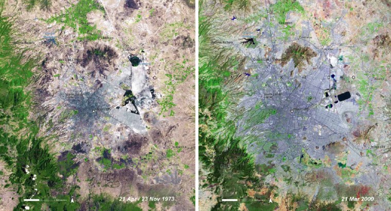
Mexico City mushrooms from a modest urban center in 1973 to a massive blot on the landscape in 2000, while Beijing shows a similar surge between 1978 and 2000 in satellite pictures.
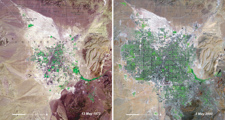
Delhi sprawls explosively between 1977 and 1999, while from 1973 to 2000 the tiny desert town of Las Vegas turns into a monster conurbation of 1 million people — placing massive strain on scarce water supplies.
"The battle for sustainable development, for delivering a more environmentally stable, just and healthier world, is going to be largely won and lost in our cities", Klaus Toepfer, director of the U.N. Environment Program, said in a statement announcing the "One Planet Many People" atlas.
‘We are all part of this’
U.N. expert Kaveh Zahedi, at a news conference Friday on the eve of World Environment Day, added that "if there is one message from this atlas it is that we are all part of this. We can all make a difference.”
Page after page of the 300-page book illustrates in before-and-after pictures from space the disfigurement of the face of the planet wrought by human activities. They include rapid oil and gas development in Wyoming, forest fires across sub-Saharan Africa and the retreat of glaciers and ice in polar and mountain areas.

Toepfer, who chose efforts to make cities greener as this year’s theme for World Environment Day, said that “cities pull in huge amounts of resources including water, food, timber, metals and people. They export large amounts of wastes including household and industrial wastes, wastewater and the gases linked with global warming.”
“Thus their impacts stretch beyond their physical borders affecting countries, regions and the planet as a whole," he added.
Shrimp farms example
The destruction of swaths of mangroves in the Gulf of Fonseca off Honduras to make way for extensive shrimp farms shows up clearly in the pictures.
The atlas makes the point that not only has the destruction left the estuary bereft of the natural coastal defense provided by the mangroves, but the shrimp themselves have been linked to pollution and widespread damage to the area’s ecosystem.
And images of the wholesale destruction of vital rainforest around Iguazu Falls — one of South America’s most spectacular waterfalls on the borders between Argentina, Brazil and Paraguay evoke comparisons with a bulldozer on a rampage.
“These illustrate some of the changes we have made to our environment,” Zahedi said. “This is a visual tool to capture people’s imaginations showing what is really happening.”
“It serves as an early warning,” he added.
Click to next page for UNEP highlights from select cities.
Africa
The population of Nairobi, Kenya, at independence in 1963 was 350,000. Since 1979, it has seen explosive growth, and the population is now well over 3 million, making it the largest African city between Johannesburg and Cairo.
Satellite images from 1979 and the present show how the city sprawled to new suburbs and slums north, east and west. The growth of development along the edge of Nairobi National Park and out to Jomo Kenyatta International Airport is also visible.
Asia-Pacific
Beijing, China’s capital, has undergone tremendous growth since the start of economic reforms in 1979, and its population now numbers some 13 million.
Satellite images show Beijing mushrooming from a small central area to one that has turned towns such as Ginghe and Fengtai into suburbs. The expansion is seen to have also gobbled up the forests to the west and the rice, winter wheat and vegetable plots that once surrounded the city.
A similar, huge expansion is seen for Delhi, India’s capital. In 1975, the city had a population of 4.4 million. By 2000, it had well over 12 million inhabitants. By 2010, it is set to rise to nearly 21 million. The latest satellite images show Delhi’s growth concentrated in the suburbs of Faridabad, Ghaziabad and Gurgaon.
Sydney is Australia’s largest city with over 4 million inhabitants. Its growth is seen spreading west toward the Blue Mountains. The urbanization is leading to more and more homes being built in the bush, making them vulnerable to summer fires.
Middle East
Riyadh, the capital of Saudi Arabia, has grown from 500,000 people in 1972 to more than 2 million as a result of migration from urban areas, a decrease in death rates and high birth rates.
The growth has been made possible by Saudi Arabia’s big investments in desalination plants that extract drinking water from seawater. Seen as a small dark and red patch in 1972, the city now shows up on satellite images as a grid-like network of blue lines that are roads, with a more than tripling of the urban area.
Europe
Turkey's Ataturk Dam, built on the Euphrates River in 1990, has had a dramatic impact on the landscape. Flooded areas appear as a large, jagged mass of black. South of the dam, around the town of Harran, the area has become green as a result of irrigation schemes made possible by the dam.
Bucharest, Romania, was a compact, well-defined city in the late 1970s. During the 1980s, villages on the outskirts were dismantled to make way for expansion and centrally planned projects. Today, partly as a result of the privatization of land, people are moving out of the center into new suburbs.
Latin America
Mexico City's population grew from 9 million in 1973 to 14 million in 1986 and is now more than 20 million. Satellite images show the city sprawling in all directions, causing significant deforestation in the mountains west and south.
Similar images reflect the doubling of the population to 5 million in Santiago, Chile.
North America
In the 1950s, Las Vegas was home to just over 24,000 people. Today, it tops 1 million, not including tourists, and may double by 2015.
Satellite images reveal how the city has spread in all directions, displacing the few vegetated lands and replacing natural desert with housing and irrigated golf courses.
The Fort Lauderdale-Miami area in Florida shows the conversion of farmland into cityscapes and the spread of Miami south and west toward the Everglades National Park.
