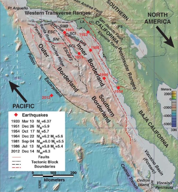
A new study calls attention to the tsunami hazard posed by a little-understood jumble of seafloor faults off the coast of Southern California — just in time to ride the wave of hype generated by the big-budget disaster movie "San Andreas."
The study's lead author, geologist Mark Legg, says a real-life offshore earthquake and tsunami wouldn't exactly follow Hollywood's script for a washout of Los Angeles or San Diego. Nevertheless, he says the hazard deserves more attention than it's received.
"That has not been looked at carefully when it comes to the potential for large earthquakes and tsunamis from offshore faults," Legg, who runs a Southern California consulting firm called Legg Geophysical, told NBC News.
Other earthquake experts insist the hazard has been looked at, but they acknowledge that the offshore faults are worthy of further study. "It's a complicated picture, and this is an important piece of it," said Lucy Jones, science adviser for risk reduction in the U.S. Geological Survey's Natural Hazards Mission Area.
Legg's latest research paper, accepted for publication in the Journal of Geophysical Research: Earth Surface, looks at a mostly underwater seismic region known as the California Continental Borderland. He said surveys of the region show a "complicated logjam" of faults caused by the smash-up of the Pacific tectonic plate and the North American plate.
The research draws upon mapping data from a depth survey in 2010 that covered more than 2,800 miles (4,500 kilometers) of fault lines on the ocean floor, plus data from earlier surveys. Legg and his colleagues focused on two fault zones in the Borderland — the Santa Cruz-Catalina Ridge Fault and the Ferrelo Fault.
Based on their measurements, the researchers determined that the seafloor crust in those areas was subject to horizontal strike-slip forces as well as vertical compression. Computer models showed that the offshore faults were capable of generating magnitude-8 earthquakes.
Legg said earlier underwater surveys found evidence of vertical movement along faults in the Borderland, amounting to as much as 10 feet (3 meters) — the kind of movement that can generate tsunami waves. "There's a smoking gun," Legg said.

Related: California Tsunami Would Have Costly Aftermath
What kind of tsunami?
Jones said there's been evidence that tsunami waves have hit Southern California going back to 1812, when a huge wave apparently generated by a 7.2 quake in the Santa Barbara Channel pushed a 283-ton trading ship a half-mile inland and then pulled it back out to sea. (The ship survived the ordeal.)
But anytime someone mentions the word "tsunami," people think of the 2004 quake and tsunami that devastated Sumatra and other Indian Ocean coastal areas, or the giant waves that hit Japan in 2011. Those tsunami waves were generated in subduction zones, where one tectonic plate dives beneath another. Jones said the "transpression" faults that are the focus of Legg's research wouldn't produce such dramatic results.
"It's not that it's not a risk," Jones said. "It's just not as big a risk as the ones we see from the big subduction zones."
The zone that's closest to Southern California is the Cascadia subduction zone, which lies off the coast of Northern California, Oregon and Washington state. A Cascadia quake in the year 1700 produced a tsunami so big that it caused damage on Japan's Pacific coast.
Legg agreed that a Borderland tsunami might not be on the scale of a Cascadia tsunami, or the Sumatra tsunami — or the "San Andreas" tsunami, for that matter.
"It doesn't have to be a Sumatra-sized tsunami," he told NBC News. "It could be a 1- or 2-meter surge. That could have a huge impact on the ports."
Related: 'San Andreas' fact and fiction from Earthquake Country
Don't panic, but be prepared
The way Legg sees it, there are two big takeaways. The first one is: Don't panic, but be prepared.
"Worrying doesn't do anyone any good," he said. "Preparedness is the key." For example, if you're on the beach and see the ocean receding dramatically, run to higher ground — because a big tsunami wave is probably on its way.
The other takeaway is that undersea faults need to be studied more closely. He pointed out that the federal government had funded seafloor depth mapping, also known as bathymetry, for Atlantic and Gulf of Mexico coastal waters — but the funding was cut before a Pacific coastal survey could be completed.
That has forced researchers to assemble a patchwork picture of Southern California's offshore faults. Legg would like to see more resources devoted to mapping the seafloor, preferably before the big waves roll in.
"This is not a billion-dollar job. Probably for a few million dollars you could finish the California Borderland," he said. "We have excellent maps of Mars and Mercury — and now they're talking about high-resolution imagery of Pluto. But we still don't have high-resolution bathymetry of our own backyard."
In addition to Legg, the authors of "High-Resolution Mapping of Two Large-Scale Transpressional Fault Zones in the California Continental Borderland: Santa Cruz-Catalina Ridge and Ferrelo Faults" include Monica Kohler, Tatsumi Shintaku and Dayanthie Weeraratne. The research is the focus of a news release from the American Geophysical Union, which publishes the Journal of Geophysical Research.
