Thick sea ice is disappearing from a broad swath of the Arctic, according to new satellite data that confirms estimates from computer models and suggests the region may be ice free during the summers sooner rather than later.
The Arctic sea ice reached a new record minimum extent in 2012, when it covered nearly half the average area it did from 1979 to 2010. The new data show the Arctic sea ice volume in the fall, when it is at its lowest, has declined more than a third between 2003 and 2012. Ice volume in the winter has declined 9 percent.
"Not only is the area getting smaller, but also its thickness is decreasing and making the ice more vulnerable to more rapid declines in the future," Christian Haas, a geophysicist at York University in Canada, told NBC News.
Sea ice extent can change in response to melting from warmer ocean and air temperatures as well as getting shifted around by winds and currents, which can push it into thick piles.
"The latter process would not change the volume of the ice," explained Haas. "But now we know that not only the area decreases, but also the thickness and therefore the total volume decreases."
The new observations are the first data analyzed from the European Space Agency’s CryoSat-2 satellite, which was launched in 2010. It uses a technique called radar altimetry to measure the thickness of the sea ice, which reveals the volume of the ice there, not just how much of the Arctic it covers.
A NASA satellite collected similar data between 2003 and 2008 and helped researchers verify a computer model used to compute ice volume based on weather records, sea-surface temperature and satellite imagery.

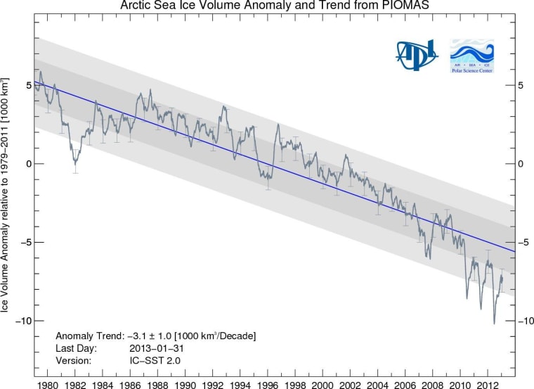
In recent years, that model, called the Pan-Arctic Ice Ocean Modeling and Assimilation System (PIOMAS), has generated some controversy because of the substantial ice loss it showed, according to the University of Washington, where it was built.
"These (new) data essentially confirm that in the last few years, for which we haven’t really had data, the observations are very close to what we see in the model," Axel Schweiger, a polar scientist with the university’s Applied Physics Laboratory, said in a news release.
"So that increases our confidence for the overall time series from 1979 to present."
In a follow-up telephone interview with NBC News, Schweiger added that for the eight-year satellite record, the estimates from PIOMAS have actually been less than what was observed.
"We knew that our system was conservative, we had a sense of that," he said, "but this confirms it."
Going forward, researchers will use the PIOMAS to forecast when the Arctic will be ice free in the summers, a phenomenon that may impact everything from global shipping to weather patterns. Some studies indicate that could come as early as 2040.
"As the satellite measurements show that not only the area decreases but also its thickness, it is actually becoming more likely that the ice will disappear sooner rather than later," Haas told NBC News.
John Roach is a contributing writer to NBC News. To learn more about him, check out his website.