IE 11 is not supported. For an optimal experience visit our site on another browser.
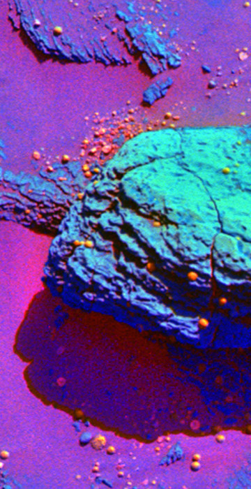
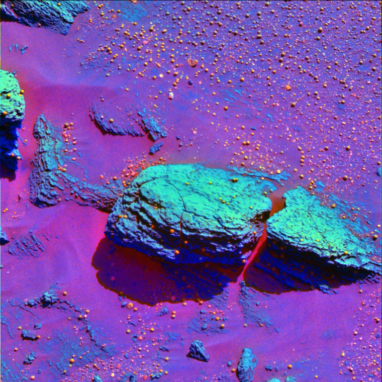
A false-color image from the Opportunity rover, released Feb. 9, accentuates the differences between a green-looking slab of Martian bedrock and orange-looking spheres of rock.  Scientists compared the \"spherules\" to blueberries embedded within and scattered around muffins of bedrock.  The spherules could have been created by volcanic eruptions, cosmic impacts or the percolation of mineral-laden water through the bedrock layers.

Science News

Greatest hits from Mars rovers

A year’s worth of highlights from NASA’s Spirit and Opportunity robots
/ 16 PHOTOS
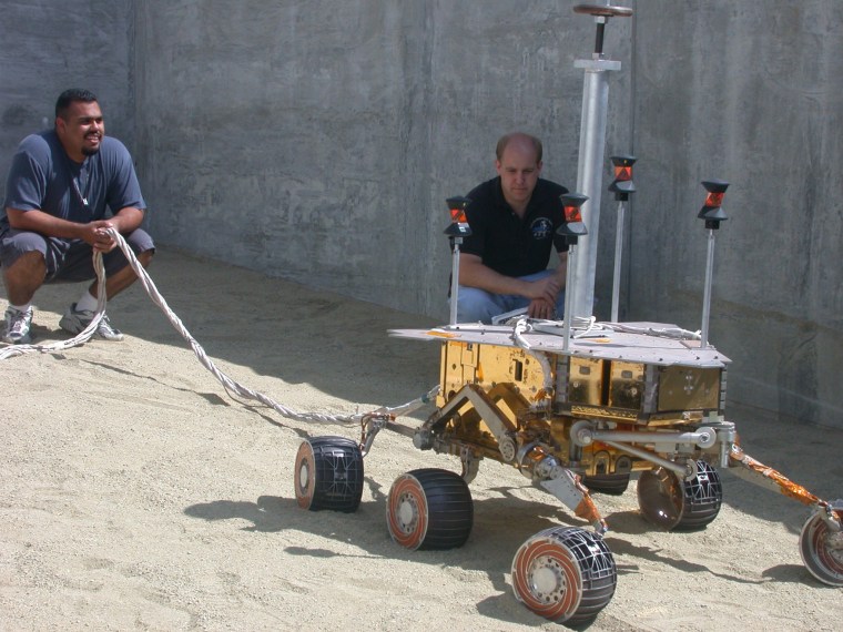
JPL engineers Eric Aguilar, left, and Joe Melko monitor the rover's performance on a sandy slope outside JPL's In-Situ Instrument Lab.

Practice run

JPL engineers Eric Aguilar, left, and Joe Melko monitor the rover's performance on a sandy slope outside JPL's In-Situ Instrument Lab.

Nasa/jpl
MARS ROVER DELTA

Blastoff to Mars

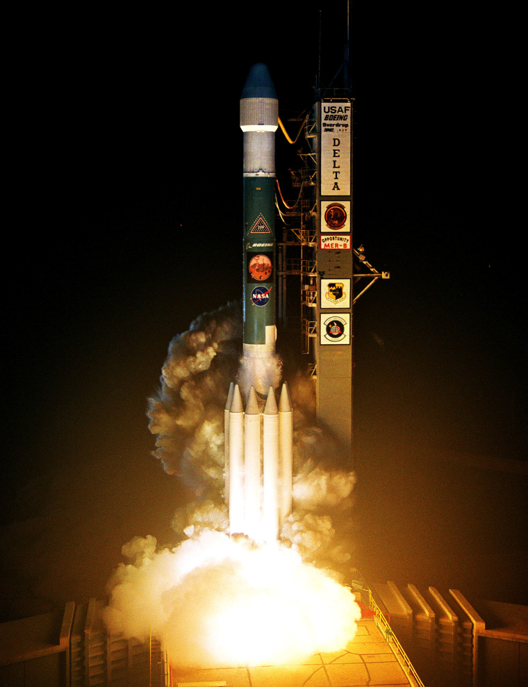
A Delta 2 Heavy rocket lifts off from Cape Canaveral Air Force Station in Florida on July 7, 2003. The rocket launched the Opportunity rover toward Mars.

BOEING
NASA Space Rover Lands On Mars

Look at that!

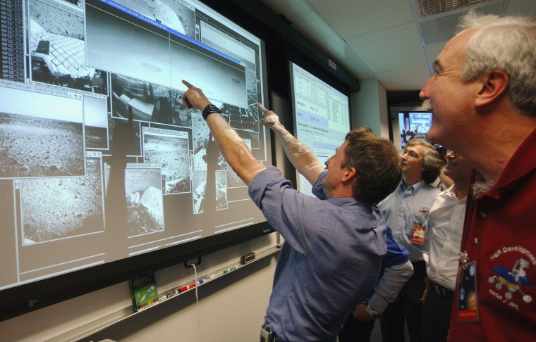
Principal rover scientist Steve Squyres points at Martian snapshots displayed on a big screen at NASA's Jet Propulsion Laboratory, beamed back from the Red Planet just after the Spirit rover's landing on Jan. 3, 2004. NASA Administrator Sean O'Keefe, at right, and mission team members watch as the images are added.
Nasa / Getty Images North America
MARS EXPLORATION ROVER SPIRIT MAKES ITS FIRST EXCURSION ON MARS

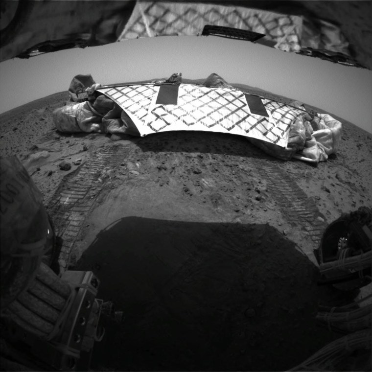
Leaving the nest

NASA's Spirit rover looks back at its own lander platform early Jan. 15, 2004, just after the mission team sent the robot out for its first spin on Martian soil. Spent air bags are crumpled along the sides of the platform. At the top of the image, the view is mirrored by the bottom of the rover's solar arrays.
Nasa / X00653
NASA JPL MARS OPPORTUNITY ROVER IMAGE SHOWING AIRBAG FOOTPRINT IN THE MARTIAN SOIL

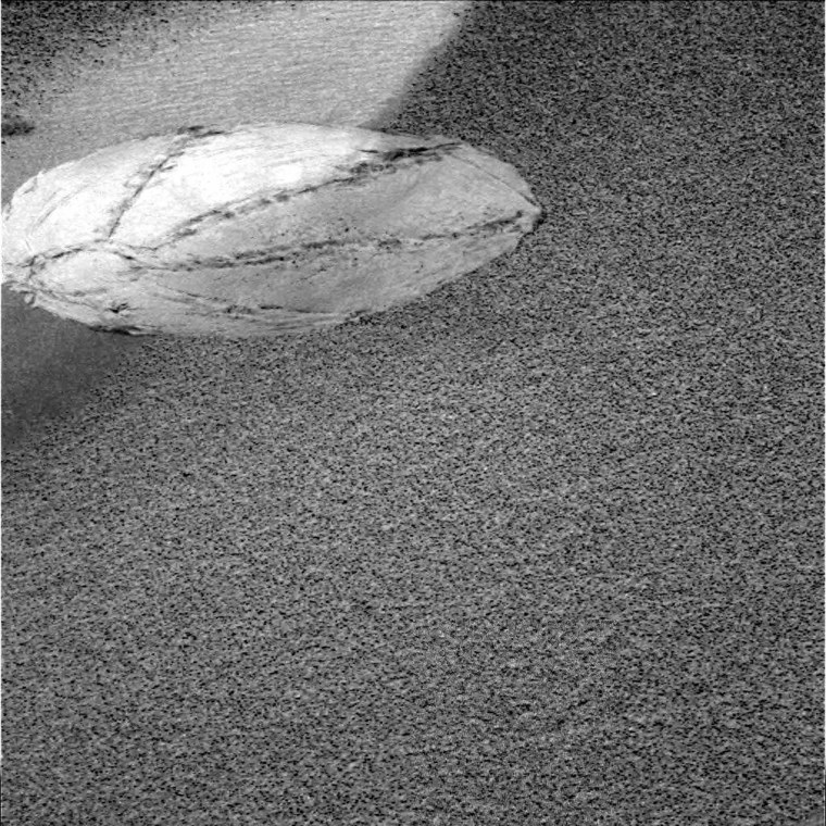
Rover's footprint

This image, taken by NASA's Opportunity rover and released Jan. 28, 2004, shows the "footprint" left by one of the rover's inflated air bags as the spacecraft bounced to its resting place on Martian soil. The circular region of the flowerlike feature is about the size of a basketball.
Nasa / X00653
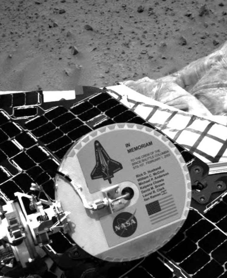
Since its historic landing, Spirit has been sending extraordinary images of its new surroundings on the red planet over the past few days. Among them, an image of a memorial plaque placed on the spacecraft to Columbia's astronauts and the STS-107 mission. 

The plaque is mounted on the back of Spirit's high-gain antenna, a disc-shaped tool used for communicating directly with Earth. The plaque is aluminum and approximately six inches in diameter. The memorial plaque was attached March 28, 2003, at the Payload Hazardous Servicing Facility at NASA's Kennedy Space Center, Fla. Chris Voorhees and Peter Illsley, Mars Exploration Rover engineers at NASA's Jet Propulsion Laboratory, Pasadena, Calif., designed the plaque. 

\"During this time of great joy for NASA, the Mars Exploration Rover team and the entire NASA family paused to remember our lost colleagues from the Columbia mission. To venture into space, into the unknown, is a calling heard by the bravest, most dedicated individuals,\" said NASA

In memoriam

NASA's Spirit rover took this picture of a plaque commemorating the fallen astronauts of the Columbia shuttle mission, which ended in disaster in February 2003. The 6-inch-wide plaque is mounted on the back of Spirit's high-gain antenna.

Nasa
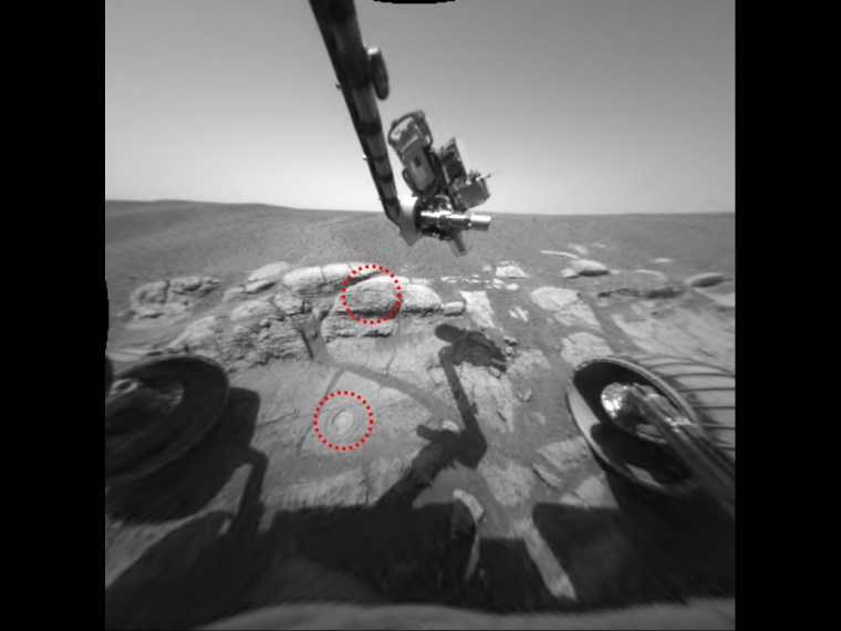
This image taken by the Mars Exploration Rover Opportunity shows the two holes that allowed scientists to peer into Meridiani Planum's wet past. The rover drilled the holes into rocks in the region dubbed \"El Capitan\" with its rock abrasion tool. By analyzing the freshly exposed rock with the rover's suite of scientific instruments, scientists gathered evidence that this part of Mars may have once been drenched in water. The lower hole, located on a target called \"McKittrick,\" was made on the 30th martian day, or sol, of Opportunity's journey. The upper hole, located on a target called \"Guadalupe\" was made on the 34th sol of the rover's mission. This image was taken on the 35th martian day, or sol, by the rover's hazard-avoidance camera. The rock abrasion tool and scientific instruments are located on the rover's robotic arm.

RAT bites

This image, taken by the Opportunity rover on Feb. 28, 2004, shows two holes that allowed scientists to peer into Mars' wet past. The rover's Rock Abrasion Tool, or RAT, drilled the holes (indicated by red circles) into rocks in the region dubbed "El Capitan." An analysis of the drilled rock helped scientists determine that this part of Mars was once drenched in water.
Nasa/jpl

Bedrock beauty

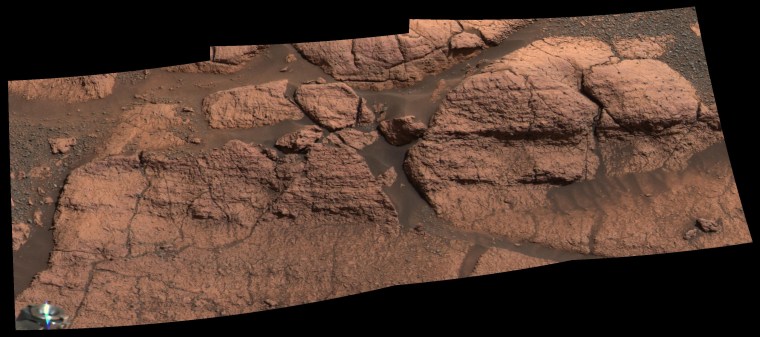
A mosaic of images from NASA's Opportunity rover shows the rock region dubbed "El Capitan," which lies within a larger outcrop near the rover's landing site. The outcrop represents the first bedrock ever seen up close on Mars. This image was released March 2, 2004.

A false-color image from the Opportunity rover, released Feb. 9, accentuates the differences between a green-looking slab of Martian bedrock and orange-looking spheres of rock.  Scientists compared the \"spherules\" to blueberries embedded within and scattered around muffins of bedrock.  The spherules could have been created by volcanic eruptions, cosmic impacts or the percolation of mineral-laden water through the bedrock layers.

Purple Planet

A false-color image from the Opportunity rover, released Feb. 9, 2004, accentuates the differences between a green-looking slab of Martian bedrock and orange-looking spheres of rock. Scientists likened the "spherules" to blueberries embedded within and scattered around muffins of bedrock. The spherules are thought to have been created by the percolation of mineral-laden water through the bedrock layers.
Nasa / Jpl / Cornell
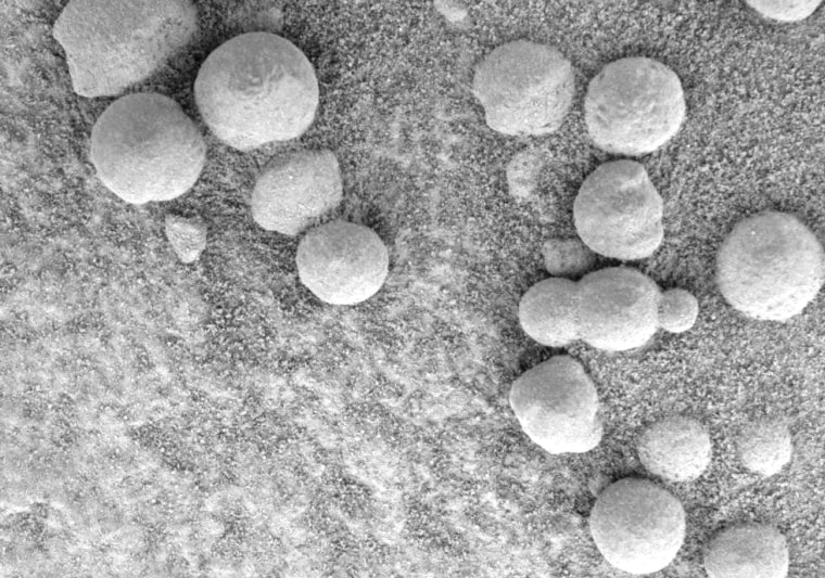
This microscopic image, taken at the outcrop region dubbed \"Berry Bowl\" near the Mars Exploration Rover Opportunity's landing site, shows the sphere-like grains or \"blueberries\" that fill Berry Bowl. Of particular interest is the blueberry triplet, which indicates that these geologic features grew in pre-existing wet sediments. Other sphere-like grains that form in the air, such as impact spherules or ejected volcanic material called lapilli, are unlikely to fuse along a line and form triplets. This image was taken by the rover's microscopic imager on the 46th martian day, or sol, of its mission.

A scoop of berries

This microscopic image, taken at the outcrop region dubbed the "Berry Bowl" near the Opportunity rover's landing site, shows spherelike grains of rock or "blueberries." Of particular interest is the blueberry triplet, which indicates these geologic features grew in pre-existing wet sediments. This image was taken March 11, 2004.


Nasa/jpl/cornell/usgs
This approximate true-color panorama, dubbed \"Lion King,\" shows \"Eagle Crater\" and the surrounding plains of Meridiani Planum. It was obtained by the Mars Exploration Rover Opportunity's panoramic camera on sols 58 and 60 using infrared (750-nanometer), green (530-nanometer) and blue (430-nanometer) filters.

This is the largest panorama obtained yet by either rover. It was taken in eight segments using six filters per segment, for a total of 558 images and more than 75 megabytes of data. Additional lower elevation tiers were added to ensure that the entire crater was covered in the mosaic.

This panorama depicts a story of exploration including the rover's lander, a thorough examination of the outcrop, a study of the soils at the near-side of the lander, a successful exit from Eagle Crater and finally the rover's next desination, the large crater dubbed \"Endurance\".

A last look back

The "Lion King" panorama, captured by the Opportunity rover March 24 and 26, 2004, is a wide-angle view of Eagle Crater and the surrounding plains. Opportunity's landing platform is visible in the center, with tracks leading out of the crater.

As NASA's Mars Exploration Rover Opportunity creeps farther into \"Endurance Crater,\" the dune field on the crater floor appears even more dramatic. This false-color image taken by the rover's panoramic camera shows that the dune crests have accumulated more dust than the flanks of the dunes and the flat surfaces between them. Also evident is a \"blue\" tint on the flat surfaces as compared to the dune flanks. This results from the presence of the hematite-containing spherules (\"blueberries\") that accumulate on the flat surfaces. 

Sinuous tendrils of sand less than 1 meter (3.3 feet) high extend from the main dune field toward the rover. Scientists hope to send the rover down to one of these tendrils in an effort to learn more about the characteristics of the dunes. Dunes are a common feature across the surface of Mars, and knowledge gleaned from investigating the Endurance dunes close-up may apply to similar dunes elsewhere. 

Before the rover heads down to the dunes, rover drivers mu

Dunes of Mars

A false-color view from NASA's Opportunity rover, released Aug. 6, 2004, shows the dune field at the bottom of Endurance Crater. The bluish tint indicates the presence of hematite-containing spherules ("blueberries") that accumulate on the flat surfaces of the crater floor.

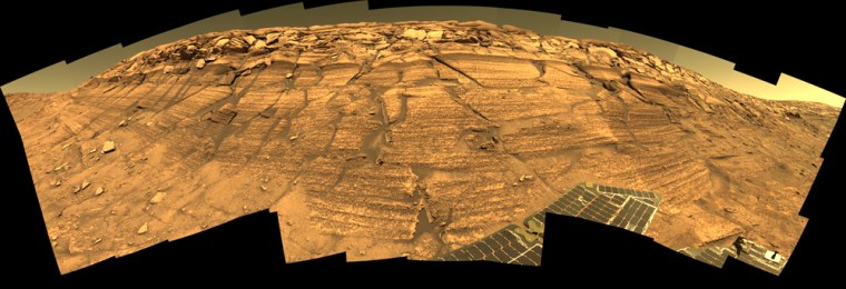
NASA's Mars Exploration Rover Opportunity captured this view of \"Burns Cliff\" after driving right to the base of this southeastern portion of the inner wall of \"Endurance Crater.\" The view combines frames taken by Opportunity's panoramic camera between the rover's 287th and 294th martian days (Nov. 13 to 20, 2004). This is a composite of 46 different images, each acquired in seven different Pancam filters. It is an approximately true-color rendering generated from the panoramic camera's 750-nanometer, 530-nanometer and 430-nanometer filters. The mosaic spans more than 180 degrees side to side. Because of this wide-angle view, the cliff walls appear to bulge out toward the camera. In reality the walls form a gently curving, continuous surface.

Wide-angle walls

NASA's Opportunity rover captured this view of "Burns Cliff" within Endurance Crater on Mars during the week of Nov. 13-20, 2004. The rover's solar arrays can be seen at the bottom of this true-color mosaic of 46 images. Because of the wide-angle view, the cliff walls appear to bulge out toward the camera. In reality, the walls form a gently curving, continuous surface.

Nasa/jpl/cornell
Clouds add drama to the sky above \"Endurance Crater\" in this mosaic of frames taken by the navigation camera on NASA's Mars Exploration Rover Opportunity at about 9:30 a.m. on the rover's 290th sol (Nov. 16, 2004). The view spans an arc from east on the left to the southwest on the right. 

These clouds are part of a band that forms near the equator when Mars is near the part of its orbit that is farthest from the Sun. For Opportunity (and Spirit and the rest of the southern hemisphere), this occurs in late fall and early winter. During this period, atmospheric temperatures and the amount of water vapor combine to form large-scale clouds. These clouds look like Earth's cirrus clouds and share other similarities with cirrus clouds in that they are believed to be composed entirely of water-ice particles with sizes on the order of several micrometers (a few ten-thousandths of an inch).

Martian clouds

Clouds add drama to the sky above Endurance Crater in this mosaic of frames taken by the navigation camera on NASA's Opportunity rover on the morning of Nov. 16, 2004. The view spans an arc from east on the left to the southwest on the right. These clouds are part of a band that forms near the equator when Mars is near the part of its orbit that is farthest from the sun.
Nasa/jpl
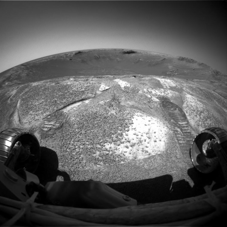
NASA's Mars Exploration Rover Opportunity climbed out of \"Endurance Crater\" during the rover's 315th sol (Dec. 12, 2004), and used its front hazard-avoidance camera to look back across the crater from the rim. The rover spent just over six months inside the stadium-sized crater, examining in detail the tallest stack of bedrock layers ever seen up close on a foreign planet.

Farewell to Endurance

After spending six months studying rocks inside Endurance Crater, NASA's Opportunity rover climbed out Dec. 12, 2004, and used its front hazard-avoidance camera to look back across the stadium-sized crater from the rim.

Nasa / Jpl
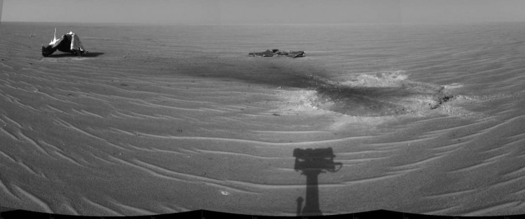
NASA's Mars Exploration Rover Opportunity gained this view of its own heat shield during the rover's 325th martian day (Dec. 22, 2004). The main structure from the successfully used shield is to the far left. Additional fragments of the heat shield lie in the upper center of the image. The heat shield's impact mark is visible just above and to the right of the foreground shadow of Opportunity's camera mast. This view is a mosaic of three images taken with the rover's navigation camera.

Alien junkyard

NASA's Mars Exploration Rover Opportunity gained this view of its own heat shield during the rover's 325th martian day (Dec. 22, 2004). The main structure from the successfully used shield is to the far left. Additional fragments of the heat shield lie in the upper center of the image. The heat shield's impact mark is visible just above and to the right of the foreground shadow of Opportunity's camera mast. This view is a mosaic of three images taken with the rover's navigation camera.

Nasa / Jpl
1/16