The scene plays out whenever waves of twisters sweep through a populated area: Residents scramble for shelter with just minutes of warning — and sometimes there's no warning at all. If we can predict where hurricanes are heading days in advance, why can't we do the same for tornadoes?
"With a hurricane, we get a precise warning, and you know pretty well where it is. We're just forecasting its evolution," explained Joshua Wurman, president of the Center for Severe Weather Research in Boulder, Colo. "But with tornadoes, we want to forecast them before they're there. We're trying to forecast their birth, in addition to their evolution, and that's a much harder problem."
It's a problem that experts on severe weather have been struggling with for decades. The stakes are high: Tornadoes — rotating columns of air that form over land — are the most violent storms on the planet, killing scores of people and averaging a billion dollars in property damage annually. But the difficulty is high, too: Twisters are so localized and so brief in duration (generally lasting less than 10 minutes) that it's hard to say exactly where and when they'll touch down.
The average lead time between a tornado warning and a tornado touchdown is 13 minutes, according to the National Weather Service. A quarter of the time, there's no advance warning at all.
Does that sound grim? Maybe it shouldn't.
"We're a whole lot better than we used to be," said Harold Brooks, a research meteorologist at the National Oceanic and Atmospheric Administration's National Severe Storms Laboratory in Norman, Okla. "Thirty years ago, 75 percent of all tornadoes didn't have a warning in advance."
Devil is in the details
Brooks and Wurman both say forecasters have gotten good at forecasting the broad outlines of tornado-worthy weather. They knew, for instance, that Arkansas was in for a string of strong storms this weekend. "But we have almost no skill predicting which of those storms will make the big tornadoes," Wurman said. "We also have very little skill predicting when in a storm's lifetime it will become a big tornado."
As a result, Wurman said forecasters tend to "overwarn" about tornadoes. The false-alarm rate for tornado warnings is about 75 percent. But Brooks said it's better to sound a false alarm than to risk missing a killer tornado. "That 75 percent number is a result of the fact that deciding whether this is a tornado-making storm is a fundamentally hard problem," he said.
Researchers are trying to make the problem less hard, particularly by extending the lead time for a tornado warning. With a half-hour's warning, it would be more reasonable to evacuate homes and send people to a neighborhood shelter.
"Every time we understand the process of tornado genesis better, or the process of non-tornado genesis, we see improvement," Brooks said. That requires more data, plus faster and better computer models to explain the data.
When Doppler radar systems came into operation in the early 1990s, that marked a significant jump in the accuracy of tornado forecasts. Phased-array weather radar installations could bring about a similar jump. Brooks said phased-array radar can gather as much meterological data in one minute as the current system does in four to six minutes. A pilot radar system is currently being tested in Norman.
"Phased-array could become potentially a replacement for the operational Doppler radars in less than a decade," Brooks said. "It's not a guarantee, but that would be a big help."
Scientific storm-chasers
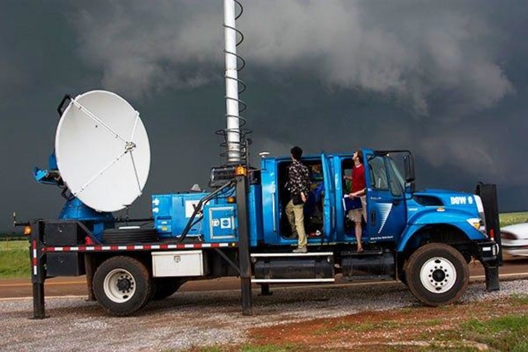
Wurman and his colleagues, meanwhile, get their data by driving radar-equipped trucks (known as "Doppler on Wheels") right through severe storms — kind of like the tornado-chasing scientists in the movie "Twister."
"What we need to be doing is probing these storms as they're making tornadoes, or not making tornadoes," Wurman said. His group sat out the past weekend's wave of twisters because the terrain wasn't conducive to making scientific observations, but they're primed for future storms this season.

The Doppler on Wheels project already may have found one of the trigger mechanisms for twisters: a secondary surge of cold air out of a thunderstorm. "It's a second push of air, behind the first one, and it happens at least in some cases before a tornado forms," Wurman explained. "It's possible that helps focus the rotation [of winds] near the ground. ... Right now we're in the stage of the scientific process where that theory needs to get firmed up."
The real trick is to find better ways to turn whirlwinds of data into more accurate prediction models for future storms.
"All of these things are evolving, but they're evolving slowly," Wurman said. "The problem is tough. There's been no 'eureka' moment. If it were that obvious, we would have already seen it. ... What we hope is that statistically, fewer and fewer people are likely to get killed."