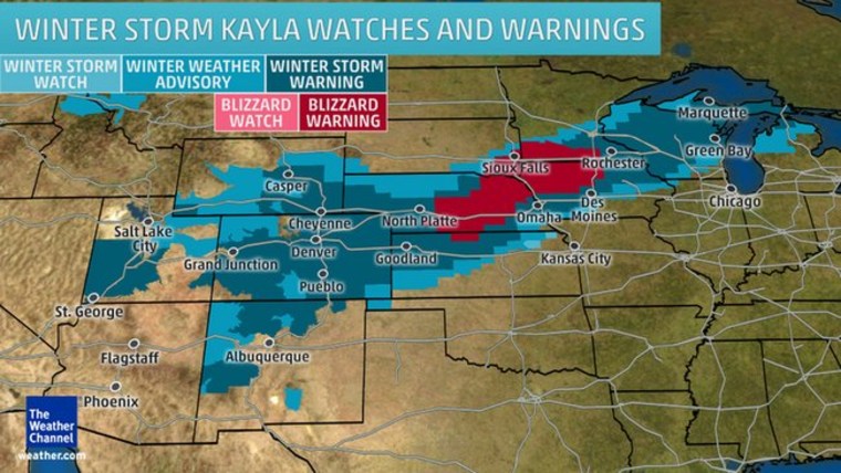
Parts of eight states were under blizzard or winter storm warnings Monday night as a massive snowstorm barreled across the Plains, threatening to dump more than a foot of new snow and snarl traffic for millions of people Tuesday.
The storm is likely to pack a wallop from Nebraska and Wyoming to southeastern Wisconsin once it moves out overnight from of Colorado, where Pueblo and Grand Junction could end up with as much as 36 inches of snow.
More than 525 arrivals and departures were canceled Monday at Denver International Airport as the city was forecast to get up to 14 inches, according to the National Weather Service. Interstate 70 was closed in both directions from Denver to Kansas because of blowing snow and whiteout conditions, the Colorado Transportation Department said Monday night.
Once it reaches the Plains, "we've got significant winds that are going to be blowing that snow around," said Danielle Banks, a meteorologist for The Weather Channel.
Blizzard warnings stretched Monday night from central Kansas across southwestern Minnesota and northwestern Iowa. Winter storm warnings covered much of Wisconsin and the rest of Nebraska and Iowa, most of Colorado, southwest Utah, northwest New Mexico, southeast Wyoming and northwest Kansas.
Near-blizzard conditions in parts of Nebraska put Red Cross chapters across the state on alert.
"This storm has the potential to affect thousands of people," said Rachelle Lipker, executive director of the Red Cross in central and western Nebraska.

Although the largest snow totals were expected in rural areas, Iowa's biggest city, Des Moines, is expected to get socked with 6 inches to a foot of snow through Wednesday. Similar amounts are in the forecast for Denver, Omaha, Nebraska, and Green Bay, Wisconsin, forecasters said.
The storm is expected to move eastward through Kansas, Nebraska and South Dakota later Monday before intensifying Tuesday as it reaches Iowa, Minnesota, Wisconsin and Michigan.
Parts of Nebraska, Kansas and Iowa could get up to 18 inches of snow by the time the storm moves into the Northeast and turns to mostly rain on Wednesday.
On the eastern side of the storm, warm air could collide with a mass of extremely cold air blowing east from the Southwest to create the threat of severe thunderstorms Tuesday in the Deep South, forecasters said.
Heavy storms are expected across eastern Arkansas, southeast Missouri and Louisiana into Mississippi, Alabama, Tennessee, Kentucky, Illinois and southern Indiana.
Coming at a time when large amounts of snow are melting, the storms could cause damaging flash floods across Eastern Kentucky into the Mid-Atlantic, the National Weather Service said.
The system has already moved through Southern California, where a woman was killed when high winds uprooted a tree and crushed her car and 80,000 homes and businesses were left without power. Blizzard warnings in effect for parts of California and Nevada were lifted early Monday.
In the California mountains, 16 inches of snow was reported at Mammoth Mountain Ski Area through Sunday afternoon. This snow shifted early Monday into parts of Nevada, Utah and Colorado, where it was already "snowing pretty good" at 6 a.m. ET, said Kevin Roth, lead meteorologist for The Weather Channel.

