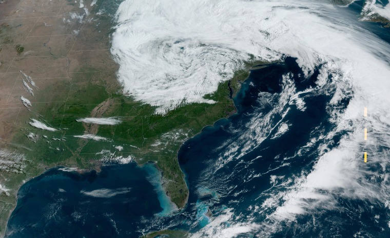
A record-setting May snowstorm is in the making, which could bring historic snow totals to parts of Wisconsin and the Upper Peninsula of Michigan.
On Monday morning, winter alerts were up across parts of the Upper Midwest and the northern Great Lakes regions for heavy snow and wind for the beginning of the week.
Snow totals just after sunrise Monday already topped 13 inches in Herman, Michigan; 11.1 inches over Three Lakes, Michigan; and 10.5 inches over Gile, Wisconsin.
After a brief lull in the heavier precipitation, a second heavy round was expected to begin during the day Monday. This round could be heavier than the first, due to the intensifying storm system producing stronger winds forecast to wrap abundant Atlantic moisture into the storm. This added moisture will lead to heavier snowfall rates and increase the amount of precipitation available to fall as snow.
The highest snow totals are expected across the Upper Peninsula of Michigan through Tuesday, where up to 18 to 24 inches could fall in a few spots. Isolated locations in the Huron Mountains could see as much as 3 feet of snow.
On Monday morning, the National Weather Service in Marquette, Michigan, noted that the ingredients were coming together to produce a winter storm that could rival a legendary May snowstorm that impacted the region more than 30 years ago.
“All these ingredients will combine in the development of a historic late spring snowstorm the likes of which we have not seen here in Upper Mi since May of 1990," it said.
The historic storm slammed the area May 9-10, 1990, dumping more than 2 feet of heavy, wet snow, crippling the region for days.
In addition to the blinding snow, high winds and flooding will also be major concerns.
Winds gusting 35-50 mph combined with the heavy snow could cause extensive tree damage and widespread power outages.
The strong north winds will also create waves on Lake Superior in the 15-20 foot range that, when they slam onto the shores in Alger and Marquette counties, could cause extensive lakeshore flooding.
While the Upper Peninsula of Michigan is no stranger to snow in May, the amount of snow expected to fall with this storm system will be extremely rare.
During the month of May, places such as Marquette and Herman average just 1.4 inches and 2.2 inches of snow, respectively.
By the time the storm wraps up Tuesday, parts of the Upper Peninsula of Michigan could pick up nearly 10 times their monthly average snowfall for the month of May.
Eastern Wisconsin and the Upper Peninsula of Michigan aren't the only regions that will see snow during this first week of May.
The anomalously cold, winterlike air mass combined with a generally unsettled pattern over the Great Lakes will also bring bursts of light snow to central and southern Michigan, northern Ohio, western Pennsylvania and the Appalachian Mountains in West Virginia. While it will be a mostly elevation-driven snowstorm in these regions, some major metro areas could see some snowflakes fly.
Detroit, Cleveland and Pittsburgh could see a few hours of light snow, especially overnight or during the early morning hours Monday into Tuesday. Little to no accumulation is expected in these areas.

