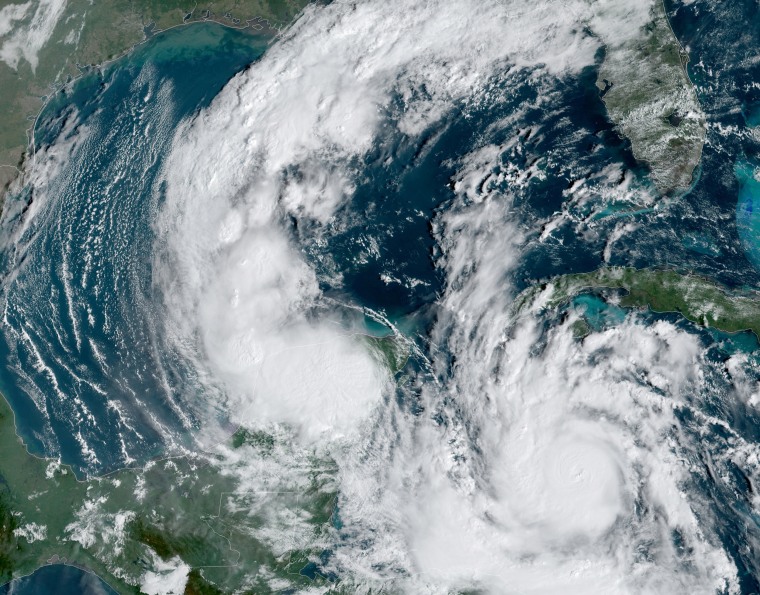
Delta, which broke a record when it became the earliest 25th named tropical storm on record, has strengthened to a hurricane, forecasters said Monday night.
Hurricane Delta had maximum sustained winds of 80 mph as it moved on a track expected to take it southwest of the Cayman Islands, near Mexico's Yucatan Peninsula, and on to the northern U.S. Gulf Coast, according to the National Hurricane Center.
Delta is on track to be the 10th storm to make U.S. landfall this season.
The previous 25th named storm record was set Nov. 15, 2005. Also, when Delta makes landfall this week, it will be the first time on record that 10 storms have made landfall in the U.S. in one season.
The hurricane's center was around 180 miles south-southeast of Grand Cayman, the hurricane center said in an 11 p.m. advisory.

A hurricane warning was in place in Mexico from Tulum to Rio Lagartos, as well as the Mexican isle of Cozumel. Hurricane warnings for the Pinar del Rio province in Cuba were replaced with a tropical storm warning by late Monday. Tropical storm warnings were also in place for parts of Mexico and the Cayman Islands.
The storm is expected to make landfall along the northern Gulf Coast by Friday.
With maximum sustained winds of 80 mph at 11 p.m., that puts Delta as a Category 1 hurricane on the Saffir-Simpson Hurricane Wind Scale. The storm continued to strengthen late Monday, and hurricane conditions were expected in the northeast Yucatan Peninsula Tuesday night.
Through the middle of the week Delta will bring 4 to 6 inches of rain, with maximum rainfall of 10 inches, to parts of the northern Yucatan Peninsula, the hurricane center said. Parts of Jamaica, western Cuba and the Cayman Islands could see 2 to 4 inches of rain. A storm surge of between 4 and 7 feet above normal tide levels could be seen along parts of the Yucatan Peninsula in the hurricane warning area.
By late Tuesday night into early Wednesday morning the storm is forecast to move into the southeastern Gulf of Mexico, and this is when people along the Gulf Coast will really need to start paying close attention.
While there is large uncertainty in the track and intensity forecasts, there is a risk of dangerous storm surge, wind and heavy rain along the coast from Louisiana to the western Florida Panhandle later in the week.
When Delta enters the northwest Caribbean Sea, warm waters will combine with favorable atmospheric conditions of weak wind shear and ample moisture that will be conducive to significant strengthening. While waters will remain warm in the central Gulf, sea surface temperatures close to the coast are significantly cooler due to upwelling from previous storms and the fall cold fronts that have made it all the way to the Gulf. Cooler waters immediately along the coast may help weaken Delta prior to landfall. This would be a shift from what other storms have done this season, like Laura and Sally, both of which intensified up until landfall.
Delta is forecast to become the 10th tropical system to make landfall on the mainland U.S. this season, breaking the 1916 record of nine landfalling storms.
And Tropical Storm Gamma, which was also spinning around the Yucatan Peninsula, weakened to a post-tropical cyclone by late Monday.
Over the weekend, Gamma became the earliest 24th named storm on record, beating the previous record set on Oct. 27, 2005.
By early Monday, it had unleashed torrential downpours causing life-threatening flash flooding and landslides for portions of Mexico.
At least six people died and thousands were evacuated, The Associated Press reported. Four of those deaths were in Chiapas when a landslide buried a home, the country's civil defense agency said.
The post-tropical cyclone was around 125 miles northwest of Cozumel, the hurricane center said at 11 p.m.
All warnings were discontinued, but it could still bring 2 to 4 inches of rain across parts of the Mexican states of Yucatan, Campeche and Tabasco, which could cause flash flooding.
But even after Gamma dissipates, its story may not be over. Later in the week, what’s left of Gamma could end up interacting and/or getting absorbed by the stronger and larger Delta.

