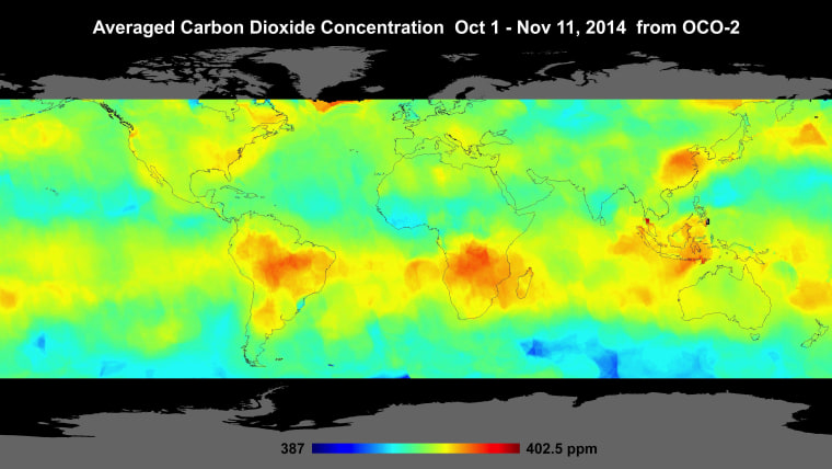
This past summer, NASA launched its first satellite devoted to measuring atmospheric carbon dioxide, a heat-trapping gas that is driving global warming. Thursday (Dec. 18), scientists with the space agency unveiled the first carbon maps obtained by the spacecraft, named the Orbiting Carbon Observatory-2, or OCO-2. OCO-2 only started collecting its first scientifically useful information at the end of September, but the initial results "are quite amazing," said Annmarie Eldering, OCO-2 deputy project scientist, based at NASA's Jet Propulsion Laboratory in Pasadena, California. [ In Photos: World's Most Polluted Places ]
In a news conference at the annual meeting of the American Geophysical Union in San Francisco, Eldering and her colleagues showed a map of the globe that uses about 600,000 data points taken by OCO-2 from Oct. 1 through Nov. 17. It shows hotspots of carbon dioxide over northern Australia, southern Africa and eastern Brazil. These carbon spikes could be explained by agricultural fires and land clearing — practices that are widespread during spring in the Southern Hemisphere, OCO-2 scientists said.
NASA scientists aren't just interested in learning more about the understudied effects of biomass burning. As OCO-2 collects more data, the scientists are hoping to compile the most complete picture to date of how carbon dioxide is distributed — geographically and seasonally. They'll also look at the places where that carbon dioxide is removed.
OCO-2 launched on July 2 from Vandenberg Air Force Base in California, carried aloft by a United Launch Alliance Delta 2 rocket. About a month later, the spacecraft reached its final, near-polar orbit 438 miles (705 kilometers) above Earth. The $465 million mission was more than a decade in the making. The original OCO spacecraft crashed into the Pacific Ocean in February 2009, after a failure with its rocket.
— Megan Gannon
This is a condensed version of a report from Live Science. Read the full report. Follow Megan Gannon on Twitter. Follow us @livescience,Facebook & Google+.
