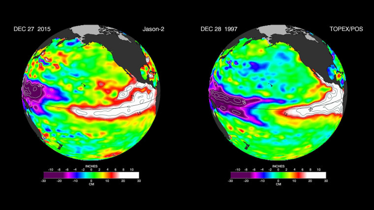
The El Niño currently wreaking havoc around the world is forecast to only worsen in 2016 — and NASA experts fear it could get as bad as the most destructive El Niño ever.
A new satellite image of the weather system "bears a striking resemblance to one from December 1997" — the worst El Niño on record — which was blamed for extreme weather, including record rainfall in California and Peru, heat waves across Australia, and fires in Indonesia. The severe conditions resulted in an estimated 23,000 deaths in 1997 and 1998.
This year's El Niño has already caused wild conditions for much of the United States.: It contributed to the reasons why many Americans experienced a balmy Christmas Eve, with temperature peaking in the 70s in places along the East Coast, and is responsible for deadly storms and near-record flooding in the South and Midwest.
It also has been tied to the worst floods in five decades in South America.
But a Dec. 27 satellite image from NASA's Jet Propulsion Laboratory, which measures sea surface heights, implies the worst of the droughts and flooding are still to come — a forecast that is troubling to humanitarian relief agencies.
"The El Niño weather system could leave tens of millions of people facing hunger, water shortages and disease next year if early action isn’t taken to prepare vulnerable people from its effects," aid agency Oxfam International warned in a press release.
In Ethiopia, for example, the government estimates 10.2 million people will need humanitarian assistance next year due to a drought exacerbated by El Niño, Oxfam said. In Malawi, 2.8 million people are estimated to experience food shortages before March.
In the U.S., the biggest El Niño impacts are expected in early 2016, NASA said. The National Oceanic and Atmospheric Administration forecasts "several months of relatively cool and wet conditions across the southern United States, and relatively warm and dry conditions over the northern United States," NASA said.
Matt Sitkowski, a coordinating weather producer at The Weather Channel, told NBC News that El Niño could result in a "wetter and stormier California" for the next two to three months — which could be a boon for the drought-stricken state.
"The fear is some of these storms come and you get too much at once, which could lead to flooding concerns," he added. "It doesn't take much in parts of California."
The East Coast could easily be affected, too. The 1997-1998 El Niño caused a crippling ice storm in New England and southeastern Canada.
El Niños are triggered when winds in the Pacific weaken or reverse direction, resulting in a warming of the ocean in the central and eastern Pacific, mainly along the Equator. Clouds and storms follow the warm water, altering jet stream paths and storm paths around the world.

They typically peak late in the year: The name "El Niño" was coined by Peruvian sailors, who were first to notice unseasonably warm water around Christmastime (El Niño is Spanish for "the boy," or "Christ child").
They occur naturally every two to seven years.
