Californians may be used to hearing about the threat of potentially deadly earthquakes, but a new study finds that quake-triggered tsunamis pose a greater risk to Southern California than previously thought.
Tsunamis are monster waves that can reach more than 100 feet (30 meters) high. They are often caused by earthquakes; the 2004 Banda Aceh earthquake and tsunami killed about 250,000 people, while the 2011 Tohoku earthquake and tsunami that struck offshore of Japan killed about 20,000 people and triggered a nuclear disaster.
Tsunamis increase in size as the depth of water in which they occur decreases. Since water depth is usually shallow near coastlines, tsunamis can grow as they approach land, becoming particularly dangerous along heavily populated coastlines, such as those in Southern California, the researchers said. [10 Tsunamis That Changed History]

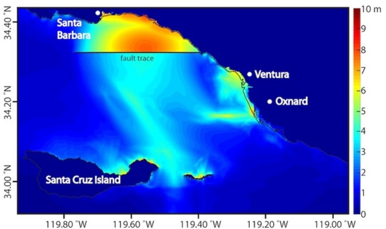
Scientists focused on the Ventura Basin in Southern California, which has offshore faults that can probably generate earthquakes of magnitude 7 or greater. The researchers created 3D models of ruptures on the 31-mile-long (45 kilometers) Pitas Point and 22-mile-long (35 km) Lower Red Mountain undersea faults.
Although homes and buildings on the coastlines directly opposite these faults would naturally be vulnerable to any tsunamis, until now, additional low-lying areas farther to the east were not necessarily expected to be in harm's way. The new study suggests the cities of Ventura and Oxnard might be under greater threat of tsunami flooding than was previously thought.
In the computer simulation, a tsunami generated by a magnitude-7.7 earthquake on the Pitas Point and Lower Red Mountain faults divided in two. One wave moved north toward Santa Barbara, reaching the city about 5 minutes after the quake. The other wave moved south toward Santa Cruz Island, but the shape of the coastline and seafloor then unexpectedly caused the southward wave to change direction toward the cities of Ventura and Oxnard.
Related: Tsunami Could Hit California, But Not Like in 'San Andreas' Quake Movie
The simulation showed the tsunami could reach up to 23 feet (7 m) high at Ventura and Oxnard and flood up to 1.2 miles (2 km) inland less than 30 minutes after the quake, penetrating twice as far inland at some locations as California's official tsunami-inundation line.
"This is a severe, but plausible, scenario," study lead author Kenny Ryan, a geophysicist at the University of California, Riverside, told Live Science.
The scientists detailed their findings in the Aug. 18 issue of the journal Geophysical Research Letters.
This is a condensed version of a report from Live. Science. Read the full report. Follow Live Science @livescience, Facebook & Google+.
More from Live Science:
- The 10 Biggest Earthquakes in History
- Image Gallery: This Millennium's Destructive Earthquakes
- 7 Ways the Earth Changes in the Blink of an Eye
Copyright 2015 LiveScience, a Purch company. All rights reserved. This material may not be published, broadcast, rewritten or redistributed.