Scientists and engineers are enjoying success both on the surface of the red planet and in orbit around Mars.
NASA’s Opportunity Mars rover is closing in on the huge Victoria Crater at Meridiani Planum. The robot has rolled into position nearby to make “rim shots”—using its cameras to take longing looks at the crater’s opposite wall.
It has been an arduous 20-month trek for the Mars machine to pull up to the sprawling Victoria Crater—equivalent of eight football fields placed end to end—a goal hungered by researchers since late 2004.
“We’re currently about 50 meters [164 feet] from the rim of Victoria crater,” said Steve Squyres, lead Mars Exploration Rover scientist from Cornell University in Ithaca, New York.
Squyres described to SPACE.com the scene ahead and locations that are likely to become very familiar in the days to come. The closest point on the rim is an alcove that rover team members call Duck Bay. Immediately to the left (northeast) of Duck Bay is a promontory named Cape Verde. To the right (south) of Duck Bay is another promontory named Cabo Frio.
“We will first reach the rim of Victoria at Duck Bay, with good views from there of Cape Verde, Cabo Frio, and much of the crater interior,” Squyres said. Once at that location, the rover will use its set of navigation cameras, as well as acquire portions of the landscape with its Panoramic Camera. The rover will also utilize, to some degree, its Mini-Thermal Emission Spectrometer, or Mini-TES, which can pick up infrared radiation emitted by objects.
The primary purpose of all this remote sensing will be to select the location for a big Panoramic Camera picture-taking session, Squyres explained. “I expect that the site we select will be either the tip of Cape Verde or the tip of Cabo Frio…but we’ll see.”
Slideshow 12 photos
Month in Space: January 2014
Squyres added that Opportunity will be driven to the chosen panorama location, fire up its Panoramic Camera “and take the coolest picture of the surface of Mars you’ve ever seen.”
“The real promise that craters give us is that they allow us to view into the 3rd dimension,” said David Des Marais, an astrobiologist at NASA’s Ames Research Center at Moffett Field in Mountain View, Calif. He is a science team member for Opportunity and its twin, the Spirit Mars robot—also busy at work at Gusev Crater elsewhere on the planet.
Thanks to Victoria Crater, rover scientists can study, for example, how long a watery environment may have existed at that locale. Furthermore, did it persist long enough to be able to sustain life as we know it?
Attack plan
The general attack plan for the 2,625 feet (800 meters) wide crater is to first map out the terrain that’s inside the feature. A large dune field is at the bottom of Victoria.
Opportunity is approaching this tantalizing target, generally from the northwest.
However, preliminary evidence from orbit indicates that southeast of the crater represents perhaps the most approachable trajectory to get inside the crater—if that go-ahead is given.
Des Marais said that there are important discussions to take place over the next few months: Is there enough science value by driving into Victoria Crater? If so, is that research of first-rate importance if rover handlers can’t wheel Opportunity back out?
“These are all very fundamental decisions that are going to have to be confronted,” Des Marais concluded.
Radar love
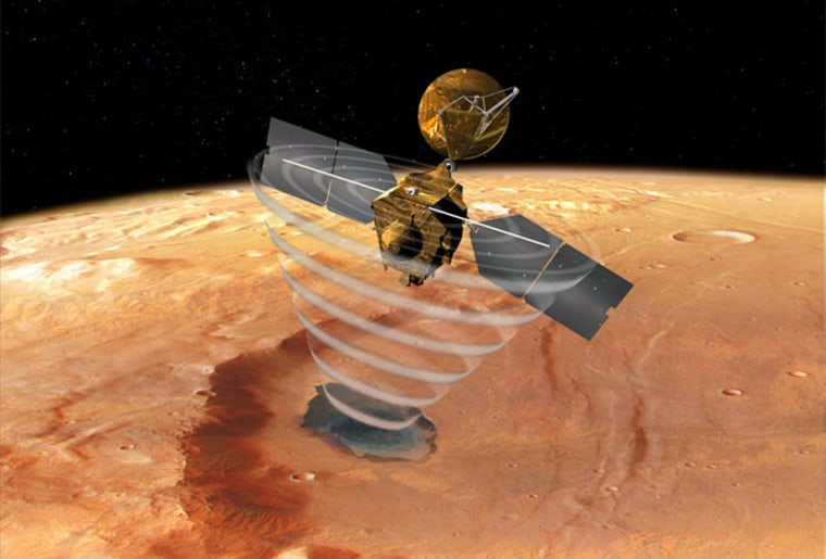
Meanwhile, sweeping high above Mars is NASA’s Mars Reconnaissance Orbiter (MRO). There’s good news with this spacecraft too.
Earth controllers have deployed the probe’s SHAllow RADar (SHARAD) antenna, an experiment provided by the Italian Space Agency and built by Astro Aerospace, a business unit of Northrop Grumman’s Space Technology sector.
SHARAD will probe Mars’ subsurface via radar waves to depths of about six-tenths of a mile (one kilometer) to find and map layers of ice, rock and, if present, liquid water.
The radar received its first radio echo from the Martian surface during a test on September 18, a checkout that verified the entire instrument is working properly.
MRO’s two-year-long main science phase will begin in November, making use of an array of science gear, including ultra-powerful camera systems.
Late last month, ground controllers successfully brought to an end a six-month-long campaign of dipping in and out of the planet’s thin atmosphere. That technique, called aerobraking, nudged MRO into a desired working orbit around the red planet.

