Alabama and Louisiana on Wednesday declared states of emergency after twisters hit some areas, while floods submerged others — all part of a severe storm system making its way to the Northeast, where significant flooding was expected Thursday.
In New Jersey, Gov. Chris Christie late Wednesday declared a state of emergency for areas along the Passaic and Delaware rivers and flood-prone Bound Brook in Somerset County.
In the South earlier Wednesday, winds tore roofs off buildings, overturned cars and injured several people. A woman died in a house fire in Mississippi that authorities believe was caused by lightning.
Two apparent tornadoes damaged buildings near Mobile in southwest Alabama, hours after several tornadoes were reported to the west near New Orleans, La.
Several tornadoes also touched down in southern Mississippi damaging some mobile homes, according to the police department in Biloxi.
The same system caused street flooding in New Orleans, dumped seven inches of rain in parts of Mississippi, triggered thunderstorms in Tennessee that ripped off part of a school's roof, and caused lightning in Florida that indirectly struck two students at separate schools — one who touched a light switch, the other a door handle.
Both were hospitalized in stable condition.
Alabama: Damage and power outages
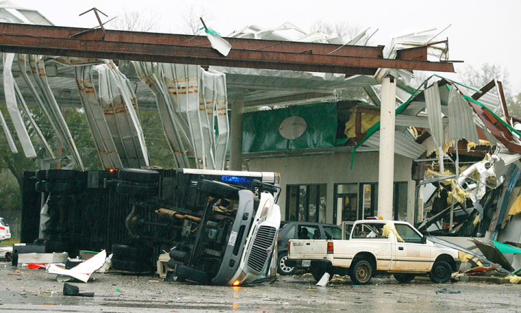
Ambulances, police cars and fire trucks with flashing lights descended on the Theodore area near Mobile after an apparent tornado struck about 8:45 a.m. local time, overturning vehicles, nearly demolishing a gas station, knocking down power lines and causing ammonia and natural gas leaks.

Three minor injuries were reported, but the entire town was rattled.
Evelyn Thibeault said she saw the twister go by her business.
"My front door flew open and a plant flew across the floor. Everything just turned white. BP (gas station) is just gone. It's horrible," said Thibeault, breathing hard during a telephone interview. "It hit a hardware store, a little country music place they have. We're all still nervous and shook up."
Across Mobile Bay in Baldwin County, a possible tornado damaged several homes and businesses in Silverhill. Nearly 1,000 homes and businesses were without electricity.
"It's still pretty rough here. We've got a few roads that are now underwater," said Paula Tillman of the county emergency agency.
Torrential rains caused flooding across a wide area of the state, and damage was reported in 17 counties by midday.
To the north, in central Alabama, storms knocked out power to more than 4,600 homes and businesses. Two Perry County schools were closed because of damage from a storm that moved through late Tuesday, and two counties in north Alabama delayed classes Wednesday because of heavy rains.
Forecasters said winds gusting to 50 mph were possible, along with up to 6 inches of rain in west Alabama, where water pooled in ditches along rural roads in Bibb County. Forecasters issued flash flood warnings and watches that covered most of the state.
In Montgomery, morning commuters struggled to open doors as the wind whistled, and heavy rain blotted out the view from tall buildings.
The state of emergency declaration allows a governor to request federal help.
Louisiana: Deluge
Tornadoes touched down early in the morning just east of New Orleans and on the heels of the Mardi Gras season, which ended Tuesday night.

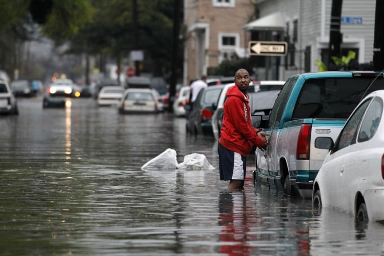
The New Orleans metropolitan area was also under a flash flood warning as downpours ranging from 1 to 3 inches flooded some streets. Some 10,000 people lost power during the storm.
Forecaster Mike Shields said one tornado touched down about 10 miles southwest of Bush in St. Tammany Parish around 5:20 a.m. — injuring one person, damaging a house, destroying a trailer and knocking down trees. Emergency officials said the woman suffered a cut on her head.
The National Weather Service also reported tornadoes in Kenner, where no damage was reported, and around Lacombe, where a roof was torn off a house.
In the village of Tangipahoa, authorities used boats and pickup trucks to evacuate a mobile home park after heavy rains caused a creek to overflow its banks, flooding about 20 to 30 homes. About 130 people were displaced, with 19 spending the night in a shelter, said Tangipahoa Parish spokesman Jeff McKneely.
Tennessee: School hit
A thunderstorm in eastern Tennessee tore a section of roof from Camp Creek Elementary School on Wednesday morning, The Greeneville Sun reported. No injuries were reported and there were no children at the school yet.
Mississippi: Roads flooded
Some buildings were damaged by the twisters and storms there, but no deaths or injuries were immediately reported.
Flash flood warnings were in effect in southeast Mississippi, and roads in several counties were flooded.
"Flooding is going to persist in some areas for a few days as water filters down into the larger rivers and waterways," said Daniel Lamb, a meteorologist with the National Weather Service in Jackson.
Storms heading east
That same storm front will bring heavy precipitation to much of the eastern United States, making flash flooding likely in already swollen flood plains from the Mississippi to the Carolinas, the Weather Channel said.
The mid-Atlantic region is under a flood watch by the National Weather Service.
Heavy rain on Wednesday and Thursday will make the low lying areas prime for more flooding in New Jersey where water already has moved into some homes and shut down roads this week.

The National Weather Service issued flood warnings through Thursday morning for several New Jersey counties and the New Jersey Office of Emergency Management is most concerned about towns along the Delaware and Passaic rivers in Morris, Essex, Bergen, Hunterdon and Mercer counties.
"The ground is saturated, the rivers are full," said Mary Goepfert, external affairs officer for the New Jersey Office of Emergency Management. "We are getting ready for a significant event."
Farther north, the Midwest can expect more rain and snow, adding to between six and 12 inches of snow around the Great Lakes.