The emergence of a newly identified atmospheric pattern is likely to provide two to three weeks advance warning that a stifling and potentially deadly heat wave will hit the U.S., according to a new study. Since current forecasts go out no more than 10 days, the additional notice could give homeowners, farmers, electric companies and hospitals critical time to prepare for severe heat.
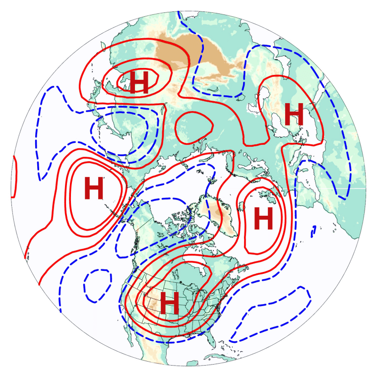
The precursor is a so-called "wavenumber 5" pattern, a sequence of alternating high and low pressure systems — five each — that ring the northern mid-latitudes several miles above the Earth's surface, according the research published Sunday in the journal Nature Geoscience.
The more amplified the pattern, the more likely a heat wave will form over the U.S. about 15 to 20 days later, the researchers explain. In some cases, the probability is quadruple what would be expected by chance alone.
The pattern "favors the genesis, the formation, of U.S. heat waves," Haiyan Teng, an associate scientist at the National Center for Atmospheric Research in Boulder, Colo., and the study's lead author, told NBC News. In the days leading up to a heat wave, the wavenumber 5 pattern slowly propagates westward around the globe, against the jet stream. Eventually, a high pressure system parks itself over the U.S.
"It just sits and you have persistent high pressure," Teng added. "And no rainfall. And hot temperature."
Fingerprint in the model
The scientists identified the pattern's connection to the pending formation of U.S. heat waves using a computer model that simulated 12,000 years of weather. The model allowed the team to collect thousands of heat wave examples and tease out the pattern from the atmospheric noise.

"Every climate model has biases, but we think this pattern is not just a pattern that exists in the model," Teng noted. "It has been noticed in nature by other studies." The problem, she explained, is that the observational record is so short — 1948-2012 — that too few extreme heat waves — just 17 — exist to reach a statistically significantly conclusion.
"In the model we can produce thousands of extreme events using this 12,000-year run and (the pattern) has a significant impact on heat waves. Therefore, we think this pattern may also have the same impact in nature."
Indeed, once the pattern was noted in the model, the team was able to tease it out from the atmospheric noise in several heat waves known from the observational record, including a series of heat waves and associated droughts in the 1950s.
Informing today and tomorrow
The identification of the pattern is important both as a tool for improved, longer-term forecasts in the current climate and advancing understanding of how the frequency and severity of heat waves may change as the planet warms, noted Noah Diffenbaugh, a climate scientist at Stanford University in California who was not involved with the new research.
"The longer lead and more accurate the warnings, the greater the potential for decreasing vulnerability and exposure in advance of an individual event," he told NBC News. "And there are many, many examples in the current climate where we haven't done that well enough and have suffered catastrophic consequences."
John Roach is a contributing writer for NBC News. To learn more about him, visit his website.
