The people of the Central Pacific don't need science to understand one possible effect of global warming.
These Micronesians, whose islands spread from near the Philippines on the west to five hours from Hawaii on the east, require no charts or graphs to know that rising ocean water is a critical and constant presence in their lives.
The reality is that, when the moon is full, the ocean waves at high tide are several feet higher than ever in the past, according to longtime island residents.
Many of the tropical islands across the Pacific depend heavily on island-hopping tourism — scuba diving and snorkeling are the main draws, along with sportfishing. But even the underwater scenery here is threatened by climate and ocean changes that affect the region's living coral reefs.
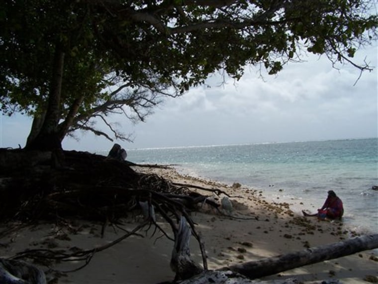
The powder sand beach of Laura village at the tip of Majuro Atoll, Marshall Islands, is shaded by an impressive stand of three-story-high casuarina pines, along with mangroves, almond, noni and huge breadfruit trees. The beach area is famous throughout the Marshalls for its beauty and tranquility.
Bougainvillea and hibiscus alternate with delicate orchids and fragrant plumeria.
The beach stretches out into the lagoon that meets the Pacific Ocean in ruffles of turquoise water. People like to take their families there to picnic and swim and play volleyball.
But today, the beach is noticeably narrower. Some of the giant trees lie half in the ocean, half on the sand, their gnarled roots reaching up like the desperate fingers of the dying. Beautiful Laura is visibly losing its sand and its trees to the invasive ocean.
Key airport road now gets washed over
The 7,897-foot asphalt runway of the Amata Kabua International Airport, on the road from the capital, Majuro, to Laura, was constructed by building a causeway across several small islands. It is just wide enough for the two-lane road and the runway, the ocean on one side, the lagoon on the other.
Drains on either side of the runway collect and store fresh rainwater. This runway, only six feet above the ocean, is a major source of fresh drinking water as well as of tourism and trade, and it's vital to the life of the Marshallese.
Sea walls have been built on both sides of the road to the airport and the runway itself, and are now being continued toward Laura.
"Sometimes, the ocean washes across this road. It never did before," says a leading Marshallese, Carmen Bigler, president of Women United Together for the Marshall Islands and the first woman member of the former Congress of Micronesia.
"We don't know what to do about the rising water. We don't want to move from our homes," Bigler said.
The Micronesians' ancestors traveled to their particular atoll or island some 2,500 years ago. Their names and their lineage are identified by their place of birth.
They want to stay here, and some are working to save their land. Charles T. Domnick, managing director of Anil Development Inc., doesn't want the ocean to wash away his business or his home. He is edging his property with abandoned cars and gutted rusted tankers.
Wilfred Kendall, education minister and former ambassador to the U.S., and his wife, Rosemary, are collecting rocks and cementing them into a sea wall around their land. Importing heavy, hard ironwood for sea walls is too costly, Kendall says.
Similar story on other islands
To the east of the Marshalls, Chuuk, formerly called Truk, is one of the four states of the Federated States of Micronesia. It has a combination of flat coral and high volcanic islands within its lagoon, which is second in size only to Kwajalein Atoll in the Marshalls.
Chuuk is famous for its World War II role when in 1944's "Operation Hailstone" the U.S. sank 41 Japanese ships within the lagoon. These have now become a world-famous attraction for divers and snorkelers.
In addition to the 18 high inhabited islands within the lagoon, there are many idyllic picture postcard flat coral islets of beach and palm trees.
In one of the high islands, Udot, Risko Walter, an educator at the College of Micronesia, says: "I woke up on my cot swimming in the water. My house is down by the beach. It was really scary."
In Chuuk's flat outer Western Islands, the ocean has washed over Pulap Atoll. Marine Resources Director Romio Oseina and former Chuuk State House Floor Leader Ruphin Mickey say salt water has killed the taro plants.
Taro is a major source of food for the islanders. Disaster teams have sailed to the area with food and supplies.
The same story is heard from the Mortlocks and other outer islands on the eastern side of Chuuk. The people of the Northern Mariana Islands, Palau, and Guam have also noticed the change.
The people in some other Central Pacific areas have even more pressing concerns.
The 10,000 people of Tuvalu are negotiating to move to New Zealand.
Kiribati, formerly the Gilbert Islands, has lost two small islands to the ocean and is facing the possibility that their 100,000 people, too, will have to find another homeland. There is less sand and the trees are falling into the ocean.
