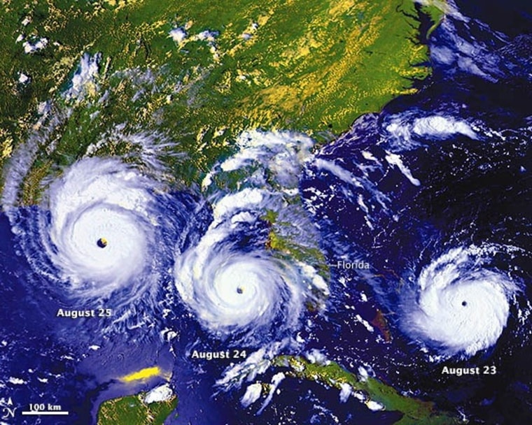
As Floridians wait to see what Tropical Storm Isaac will do, they're also remembering a storm that changed lives 20 years ago today.
Hurricane Andrew blasted onto the Florida coast on Aug. 24, 1992, and in the days that followed, the storm left 26 dead, 126,000 homes damaged or destroyed, and $26.5 billion in total damage. The toll was so great that it forced Florida to strengthen its building codes and enforce them more rigorously. Some who lived through the hurricane are still in awe of its power.
"Just to see what that kind of a storm can do, and how it can totally displace your life ... it's just amazing," said Stacy Linfors, who weathered the storm with her neighbors in the Miami area.
Today, researchers can model the force of Category 5 hurricanes like Andrew using research tools such as the "Wall of Wind" at Florida International University's International Hurricane Research Center. At the center's hangar-sized facility, 12 giant fans can whip up winds measuring up to 157 mph, blasting away the roof of a house that's built to pre-Andrew standards.
"The nation is better off" thanks to the lessons learned from Andrew, said Erik Salna, the center's associate director.

Where in the Cosmos
To mark the Hurricane Andrew anniversary, we featured a composite image showing the storm's passage over Florida as today's "Where in the Cosmos" picture puzzle on the Cosmic Log Facebook page. This picture shows the storm's position on Aug. 23, 24 and 25, 1992, as seen from orbit by the GOES-7 satellite.
Twenty years since Andrew hit, meteorologists can get a much better picture of a storm's expected route, not only because of enhanced satellite capabilities, but also because of more extensive data-collection networks and more sophisticated computer modeling for weather phenomena. Such tools indicate that Isaac is highly unlikely to become as destructive as Andrew was.
It didn't take long for Shawn Harness, Deena Perleberg and Darron Sands to recognize the satellite imagery as Andrew's track. They're eligible to receive 3-D glasses in the mail, courtesy of Microsoft Research's WorldWide Telescope project, in recognition fo their quick wits and fast typing fingers. Those red-blue specs will come in handy for looking at 3-D images of Hurricane Andrew and other storm imagery.
Click the "like" button for the Cosmic Log Facebook page and get ready for next Friday's "Where in the Cosmos" contest.
Alan Boyle is NBCNews.com's science editor. Connect with the Cosmic Log community by "liking" the log's Facebook page, following @b0yle on Twitter and adding the Cosmic Log page to your Google+ presence. To keep up with Cosmic Log as well as NBCNews.com's other stories about science and space, sign up for the Tech & Science newsletter, delivered to your email in-box every weekday. You can also check out "The Case for Pluto," my book about the dwarf planet and the search for new worlds.