Several years ago when I was in Los Angeles for a trade show, I got lost at 11 p.m. driving from downtown to my hotel near the airport. The area near the airport is not a place where a woman feels comfortable stopping to ask for directions, so I kept driving. Eventually I found my hotel, but I vowed never to rent a car again without a navigation system.
A navigation system is not a luxury. It's a safety net that ensures I can get to where I'm going without having to stop for directions or search aimlessly for a gas station.
Until recently, my first choice would have been a portable navigation system. They've had the most up-to-date maps and voice-based turn-by-turn directions, and premium models have had integrated traffic updates and local search, among other features. But the latest crop of navigation apps for smart phones work just as well as stand-alone units, and without the need to buy a new device.
Because they're resident on a phone, navigation apps also offer features that portable nav systems can't match:
- Use your phone's address book to select your destination
- Call businesses and other points-of-interest from within the app
- Use geotagging location data stored in digital pictures to guide you to the place where the photo was shot
- Find almost any local business or attraction
- Provide real-time traffic information with re-routing to avoid delays
Apps run from free to $60. Why the disparity? The expensive ones store complete maps of the U.S. and millions of points of interest, like restaurants, gas stations, stores and tourist attractions.
The benefit of having the information stored on the phone is that if you lose your data connection, the app will continue to work. This is primarily a concern for Sprint and Verizon Wireless customers, whose networks don't support calls and a data connection simultaneously. However anyone with spotty data coverage along their routes should consider an app with stored maps.
The downside of stored maps is that you often have to pay a fee to have them updated, like you do today with portable and in-car systems. Plus those maps will take up more than a gigabyte of your phone's memory. But if there's a chance I'll be left hanging without a map, I'd rather have them stored on my phone.
My favorite iPhone app with stored maps is the TomTom U.S.A. (tomtom.com; $50). In addition to its simple controls and intuitive interface, the app has a great "Help Me" feature for emergencies. With the press of a button, I can see my current location with cross streets labeled, plus the longitude and latitude for those deserted stretches of highway. I also get the emergency phone numbers and driving directions to nearby hospitals, police stations, car repair facilities and other saviors.
Garmin, the leader in portable nav systems, just introduced its first navigation app, StreetPilot for iPhone (garmin.com; $40). It has the same two-button interface: "Where To?" and "View Map" and general look and feel as the portable products. Plus you'll have real-time traffic updates, lane assist with junction view, and the ability to control your music from within the app.
A less pricey option is MotionX GPS Drive (iTunes link; 99 cents) for iPhone. It has Bing local search, and for $20 a year you can add real-time traffic.
On Android phones, your first option comes built right in. As long as you don't want stored maps, just use Google Maps with Navigation for Android devices. It's very easy to use, has Google's local search and free real-time traffic updates.
For Android users who do want maps on board, I'd recommend Navigon MobileNavigator (navigon.com; $60). It shows you which lane you should be in and has photo-realistic images or exits and signs. You'll get free, real-time traffic feeds and a feature called "Reality Scanner," which identifies nearby points of interest and shows them in a live camera view.
On BlackBerry, the best is TeleNav GPS Navigator. It's a good, basic app with real-time traffic alerts, but pricey at $9.99 a month (telenav.com).
The only area where smart phones lag behind portable nav systems is in acquiring a GPS signal. If you're unhappy with the GPS responsiveness, you can work around it with a GPS-equipped cradle mount. You need a mount anyway, but the TomTom Car Kit (tomtom.com; $120) and the Magellan Premium Car Kit (magellangps.com; $130) have their own GPS chips inside. (Note: These also serve to convert the iPod Touch a GPS navigation system.)
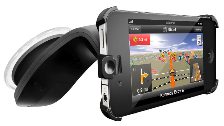
If you don't feel the need to boost your iPhone's GPS reception, you'll still need a suction mount. I like the Navigon Car Kit for iPhone (bringmobi.com; $44.95) with its sleek minimalist design.
So for my trip to Chicago next month, I'll be skipping the nav system option for my rental car and using my smart phone instead. I've already put the car kit for my phone on my packing list.
More from Techlicious:
- Smartphone Buying Guide
- Send Addresses to Your Car's Nav System from Google Maps
- Don't Let Your Nav System Lead Thieves to Your Home
Drive by Suzanne's place on Twitter or on .
