When it comes to hurricane forecasting, there's good news and not so good news. Tracking them has "improved markedly," in the words of some top U.S. scientists, but predicting their intensity is still difficult and attempts to gauge potential rainfall, storm surges and wind speeds "are comparatively in their infancy."
As hurricane season approaches, scientists offer this view in a National Hurricane Center report this month: "The skill of operational hurricane forecasting has advanced significantly during recent decades. Numerous forecast challenges remain, however, in order to address the emergency management needs of growing coastal populations that are extremely vulnerable to loss of life, property damage and economic hardship due to hurricanes."
What's improved
Forecasters are especially proud of their record on tracking the path of hurricanes during the Atlantic hurricane season, which runs from June 1 to Nov. 30.
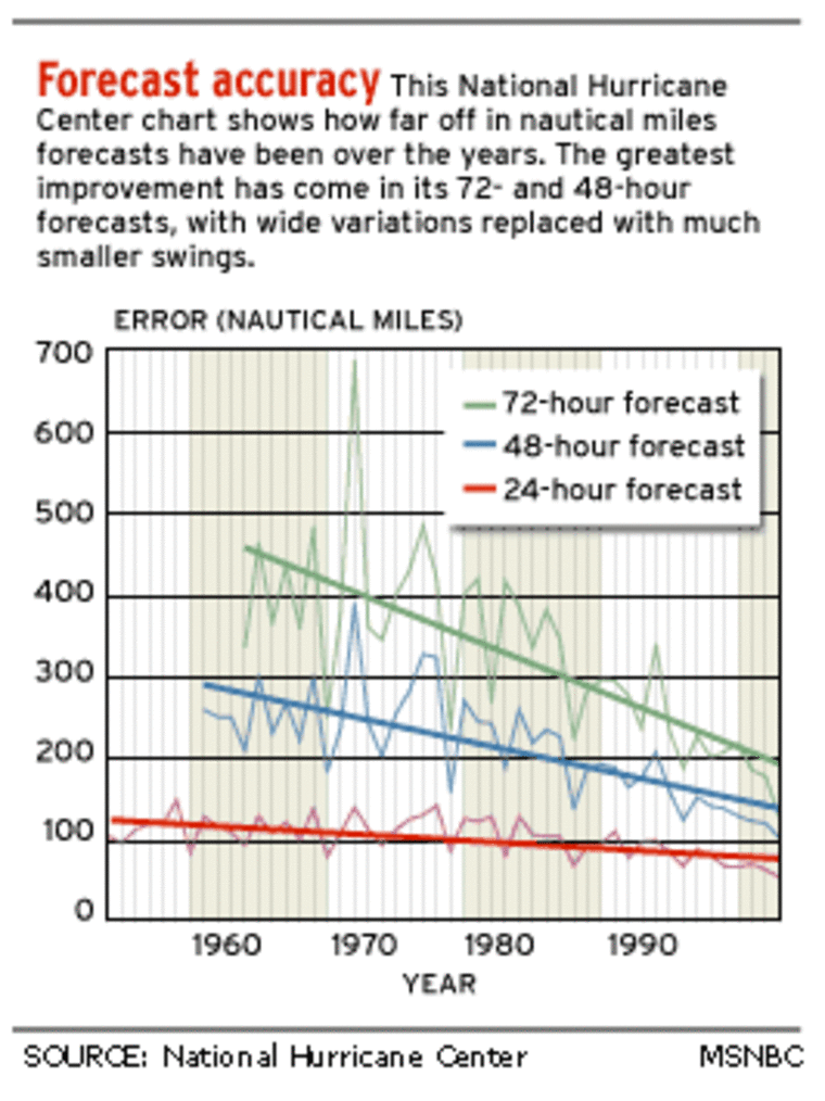
A hurricane center chart shows how the margin of error on three- and four-day tracking forecasts have been reduced significantly over the past 50 years.

"Today a three-day forecast is as accurate as those issued for a two-day prediction in the late 1980s," researchers Chris Landsea and Miles Lawrence wrote in a separate background paper. The reasons, they said, are "more accurate numerical models, more observations over the open ocean and a better understanding of the physics of hurricane movement."
The ocean observations are often the work of "hurricane hunters," aircraft that fly into a storm and drop instruments that measure certain parameters, transmitting data back to forecasters.
And since 2003, that extra tracking confidence has allowed the experts to extend the tracking forecasts to four and five days out.
Other recent improvements include:
- Faster computers: The National Weather Service earlier this year acquired computers that can calculate data much faster. “Literally, we are going from making 450 billion calculations per second to 1.3 trillion calculations per second,” service Director David Johnson said at the time.
- Wave predictor: A Texas professor is testing sensors on buoys in the Gulf of Mexico that he says provide a heads-up should a large storm trigger a giant wave.
- Intensity model: British scientists last month reported they can forecast how intense storms will be in an upcoming hurricane season by tracking certain wind patterns in July.
- Landfall predictions: Researchers at Colorado State University have created an online database — e-transit.org/hurricane/ — that uses their calculations to predict the chances of a given area being hit by a hurricane.
What's not so improved
But forecasters haven't been as successful in predicting the intensity of hurricanes.
"Three-day forecasts of intensity have not gotten substantially better at all," Landsea and Lawrence wrote. "Much work still remains to better understand and predict wind intensity changes in tropical storms and hurricanes."
A new generation of aircraft will replace the aging "hurricane hunter" fleet later this year, and officials hope that will improve intensity forecasting. The existing aircraft measure wind speed at 10,000 feet, but the new fleet will be able to measure speeds at the surface.
The scientific lag is also true of rainfall and storm surges, which can push water miles inland, causing flooding.
Last year, for example, the remnants of Hurricane Gaston unexpectedly dropped more than a foot of rain in Richmond, Va., which is about 60 miles from Chesapeake Bay, causing eight deaths. "Inland flooding and poor human judgment continue to be a lethal combination," said National Weather Service official Dean Gulezian.
So what to do?
More money would mean more science and scientists to study hurricanes, but since that's not likely the National Hurricane Center created a "testbed" group in 2001 that aims to test and quickly deploy successful forecasting technologies. It handles about a dozen projects at a time.
And researchers continue to tinker with computer models, drawing on data to produce steady, if not revolutionary, improvements. "It's incremental; we keep tweaking these models all the time," says National Hurricane Center spokesman Frank LePore.
This slow-but-steady approach isn't as sexy as some of the ideas tested in the past — among them seeding clouds with silver iodide to try to weaken hurricanes, and blanketing the ocean surface with a liquid to prevent evaporation, which feeds hurricanes. Both were found to be impractical.
"Perhaps the best solution is not to try to alter or destroy the tropical cyclones, but just learn to co-exist better with them," the hurricane center says on its Web site. "Since we know that coastal regions are vulnerable to the storms, building codes that can have houses stand up to the force of the tropical cyclones need to be enforced."
"The people that choose to live in these locations," it adds, "should be willing to shoulder a fair portion of the costs in terms of property insurance — not exorbitant rates, but ones which truly reflect the risk of living in a vulnerable region."
Low-tech 'line' to stay
One tool that the weather service will continue to use is its “skinny black line” that shows the projected path of a hurricane.
Media outlets regularly reproduce the lines, even though they have a wide margin of error, which caused some consternation last summer.
Hurricane Charley, for example, slammed into Punta Gorda, Fla., although its tracking line pointed toward the Tampa Bay area, about 90 miles north.
The weather service last March decided to stick with the line after it sought opinions from the public, media and emergency service workers, and received nearly 1,000 e-mailed responses.
The agency had looked at three options: keeping the line, using large colored dots to represent the projected path or using large circles that would encompass the projected path and the margin of error.
Scott Kiser, the tropical cyclone program manager with the weather service, said two-thirds of those who sent e-mail favored keeping the skinny line. He summed up the response as: “Show us your best forecast — we’re smart enough to figure it out.”
Five-day forecasts to stay
The weather service also said it will continue making five-day forecasts, even though critics say they are less accurate, cause needless panic and scare off tourists.
Florida Emergency Management Director Craig Fugate said he favors the five-day forecasts because people otherwise tend to wait too long to evacuate or take other precautions.
Fugate also noted that despite the four hurricanes last year, Florida had its best tourism year since before 2001.
“I didn’t see anybody in Florida panic over a five-day forecast,” he said.
