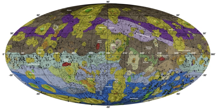
If future space travelers ever have to get around on Vesta, the second most massive body in the asteroid belt, they may well rely upon a just-released map that's based on data from NASA's Dawn mission.
The first-ever global geologic and tectonic map of Vesta appears in the December issue of the journal Icarus. It draws upon mapping data acquired by the Dawn spacecraft, which orbited the misshapen asteroid between June 2011 and September 2012.
"The geologic mapping campaign at Vesta took almost two and a half years to complete," Arizona State University's David Williams, who helped lead the effort, said in a news release. "The resulting maps enabled us to construct a geologic time scale of Vesta for comparison to other planets and moons."
Eleven papers about Vesta appear in next month's issue of Icarus. Using Dawn's data, scientists found that Vesta was shaped by a sequence of large impact events — including the impacts that created the Veneneia and Rheasilvia craters early in the asteroid's history, and the Marcia crater later on.
Dawn moved on from Vesta in 2012 and is on its way to next year's big rendezvous with Ceres, the largest asteroid and the closest dwarf planet. Several months after Dawn reaches Ceres, NASA's New Horizons probe is due to fly by the dwarf planet Pluto. If researchers play their cards right, we could soon see the first detailed maps of those dwarf worlds as well.
