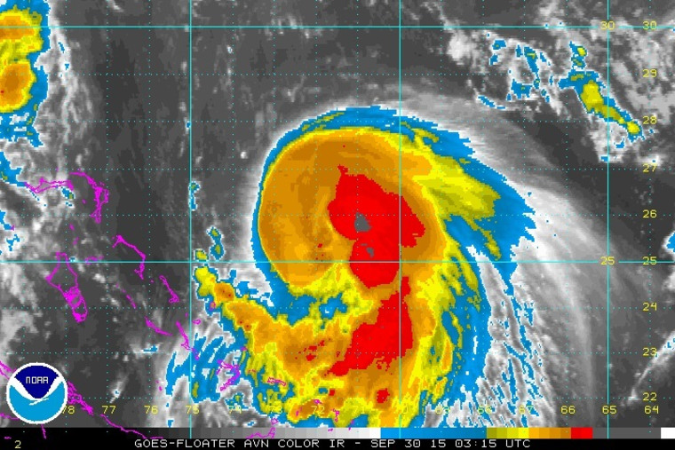
More flooding is likely along the Atlantic coast this week as the effects of soon-to-be Hurricane Joaquin piggyback on to a complex series of weather fronts that has already brought heavy rain, wind and rip currents to the coast, forecasters said Tuesday.
Emergency agencies in the mid-Atlantic and the Northeast were gearing up for thunderstorms with several inches of rain beginning Tuesday night and Wednesday.
That's when a cold front parked over the Great Lakes is expected to move east and ram into warm air arriving from Mexico and the southern Atlantic coast, said Bonnie Schneider, a meteorologist for The Weather Channel.
"It's going to saturate the area with heavy rain as we go through the next few days," Schneider said — including areas like Florida and the Carolinas, which were already saturated by strong Gulf storms last weekend that produced heavy tidal floods.
"The entire Southeast is looking at a very wet next couple of days because of this system," she said.
The National Weather Service issued flood watches from Maine to the Smoky Mountains in western North Carolina.
Several school districts in eastern Virginia — where many roads and residential areas were already beginning to flood — dismissed classes early Tuesday ahead of the storms, NBC station WSLS of Roanoke reported. Officials in Salem, Virginia, advised voluntary evacuations and opened an emergency shelter at the city's Civic Center.
The system is expected to stall near the Northeast coast into Wednesday, with flooding possible beginning overnight in northeastern New Jersey and New York's Hudson Valley, forecasters said.
New England was expected to be hit with tropical downpours beginning Wednesday, the National Weather Service said.
Then comes Round 2, when Tropical Storm Joaquin, which is forecast to become a hurricane early Wednesday, flexes its muscles.

Joaquin formed late Monday in the western Atlantic Ocean and was still a good 350 miles from the Bahamas on Tuesday night. The storm strengthened significantly Tuesday afternoon, and the Bahamas issued a hurricane watch late Tuesday.
From there, its path is hard to calculate thanks to unpredictable atmospheric patterns — it could roll into the Southeast coast, tilt north into the Northeast or even track away from the U.S. mainland entirely, the National Weather Service said.
But even if Joaquin skirts land entirely, the coast will still likely get hit with new floods, strong winds, high surf, beach erosion and coastal flooding.
Joaquin will be a "major rain-maker as we go through Saturday and Sunday," said Schneider of The Weather Channel.
The worst impacts are likely to be in the Northeast late in the weekend, according to computer models, which were tentatively forecasting as much as a foot of new rain in some parts of New England.
